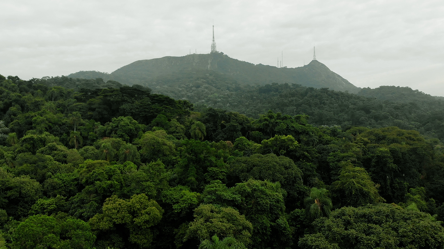
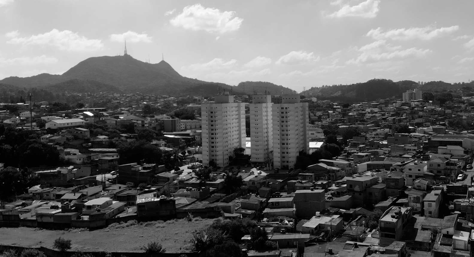
A Terra Indígena Guarani do Jaraguá preserva os últimos fragmentos de Mata Atlântica na cidade de São Paulo, um dos biomas brasileiros mais devastados desde a colonização europeia.
Além de ser uma reserva florestal de fundamental importância ambiental e climática para a metrópole paulista, onde áreas verdes são notoriamente escassas, o Jaraguá é um território de imenso valor espiritual e cultural para as comunidades indígenas que aí vivem desde tempos imemoriais.
Ka’aguy – a mata, a floresta – é uma paisagem saturada de história e memória, o patrimônio vivo dos ancestrais (humanos e não-humanos) dos povos Guarani.
TERRA INDÍGENA JARAGUÁ
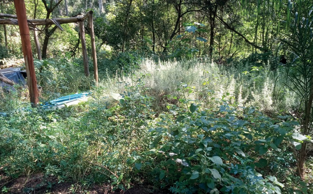
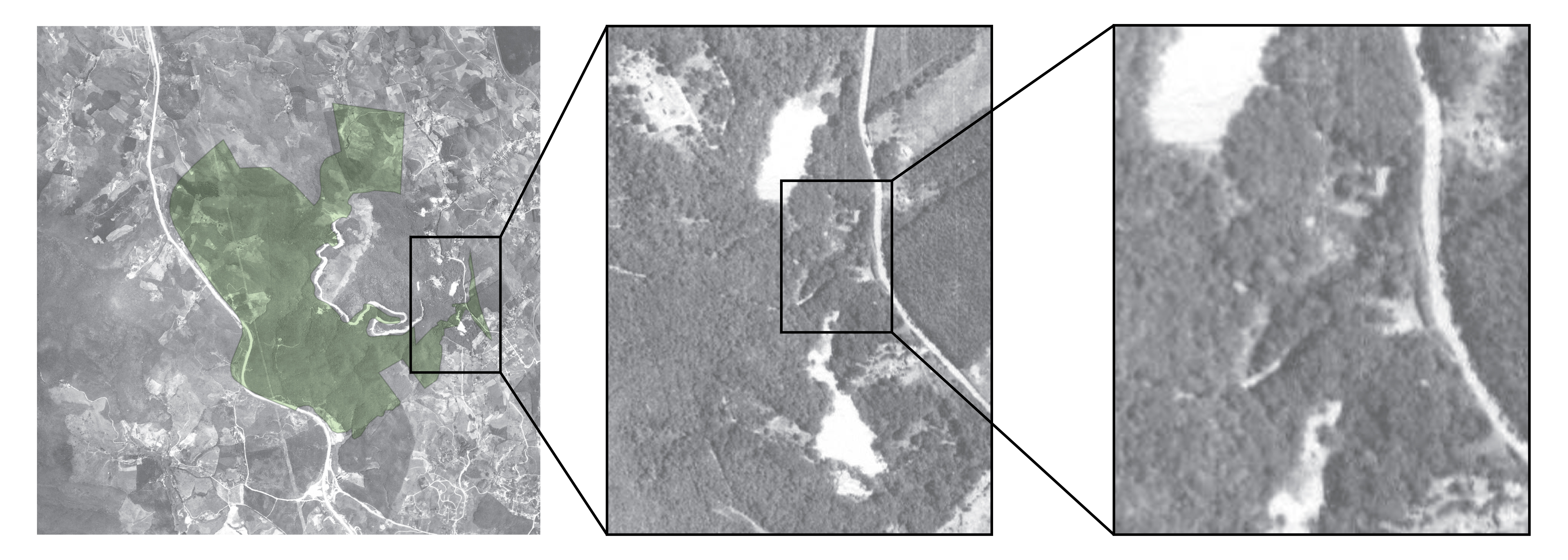
A Terra Indígena Jaraguá é um território localizado na cidade de São Paulo, tradicionalmente habitado pelo povo Guarani Mbya. A área reconhecida e demarcada pelo Estado Brasileiro abrange 532 hectares, a maior parte ainda cobertos de Mata Atlântica. Atualmente, a TI Jaraguá conta com nove Tekoas (aldeias).
TEKOA YTU
Retomada e fundação: década de 1960
Uma das mais antigas tekoas, a tekoa Ytu, “Aldeia da Cachoeira”, foi fundada pela família de Joaquim Augusto Martim e Jandira Augusto Martim, primeira Cacica da Terra Indígena Jaraguá. O nome se refere ao Ribeirão das Lavras que chega à _Tekoa _por meio de uma pequena cachoeira. Cobrindo um perímetro de certa de 1.8 hectares, foi demarcada em 1987.
TEKOA PYAU
Retomada e fundação: década de 1990.
A tekoa Pyau, traduzido como “aldeia nova”, é a segunda aldeia do processo histórico de retomada da T.I. Jaraguá. Hoje é a comunidade com maior densidade populacional da terra indígena. A tekoa está cercada pela Rodovia dos Bandeirantes e pela Rua Comendador de Matos, infraestruturas que bloqueiam sua continuidade territorial e afetaram historicamente áreas de coleta, caça e cultivo.
TEKOA ITAKUPE
Retomada e fundação: 2005
Situada no extremo norte da T.I. Jaraguá, a área onde está a Tekoa Itakupe é utilizada pelas comunidades Guarani desde as primeiras retomadas nos anos 1950 e 1960. Fundada em 2014, hoje é formada por três núcleos: Sol nascente, Toka da Onça e (confirmar como querem chamar o terceiro núcleo). Por estar localizada do outro lado do Pico do Jaraguá, próxima de suas formações rochosas, foi nomeada de Itakupe, que pode ser traduzido como “atrás da pedra”.
TEKOA ITAWERA
Retomada e fundação: 2014
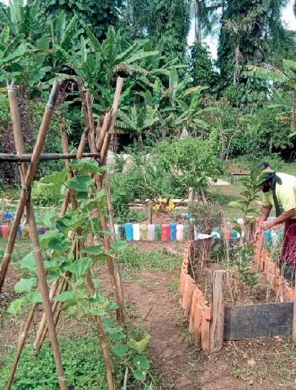
Fundada pela Cacica Ara Poty (Maria) em 2014, a Tekoa Itawera recuperou uma área antes destinada ao descarte de lixo. Hoje, a comunidade se dedica à recuperação ambiental e cultural, com ações como o reflorestamento com espécies nativas, o cultivo de alimentos tradicionais como o milho Guarani, bem como um vasto trabalho de artesanato. O nome da aldeia pode ser traduzido como “pedra reluzente”.
TEKOA ITAENDY
Retomada e fundação: 2017
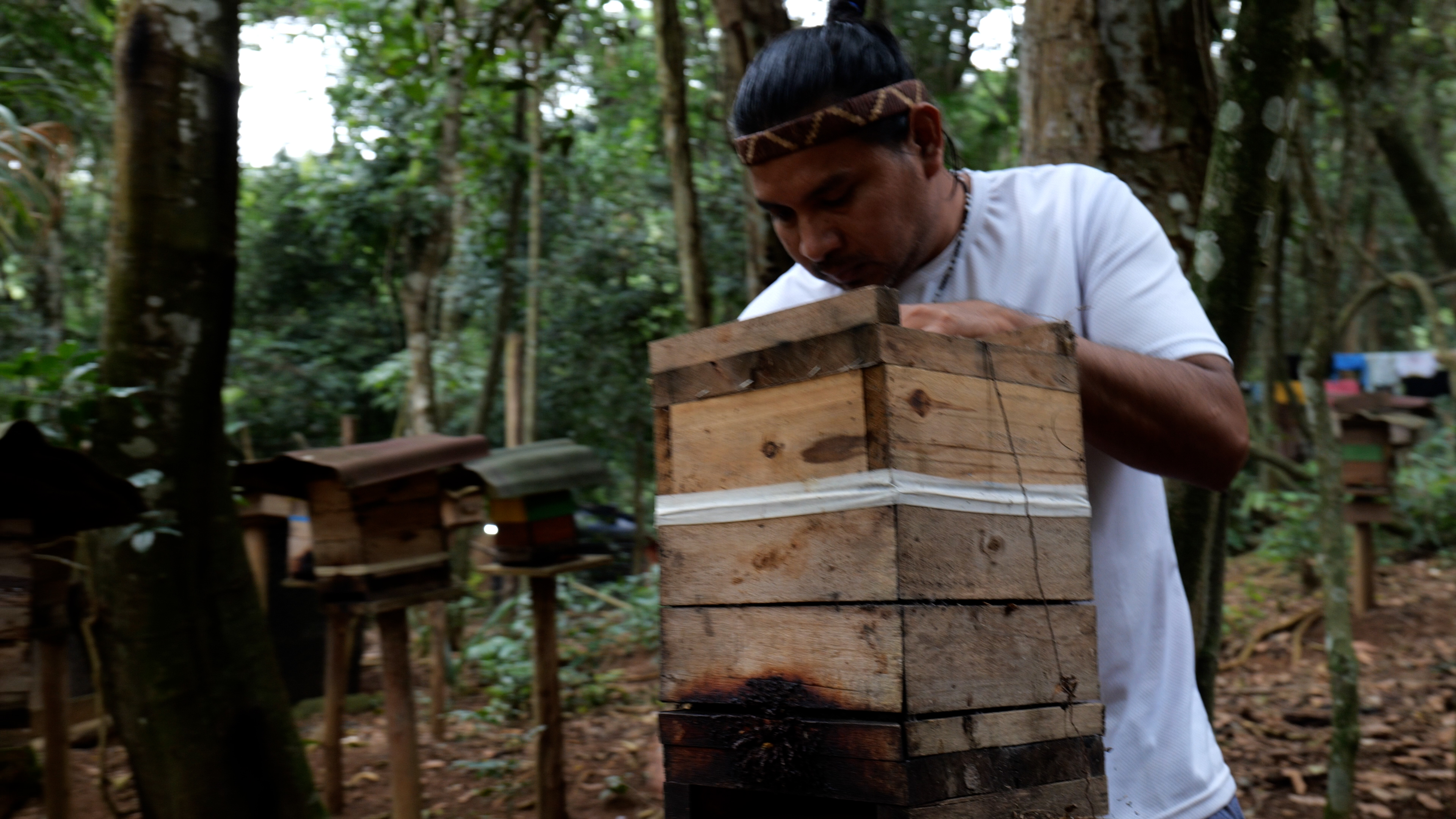
Desde sua retomada em 2017, a Tekoa Itaendy, “aldeia da pedra amarela”, vem promovendo práticas de manutenção da biodiversidade como o reflorestamento com espécies nativas, plantio de roças com alimentos tradicionais, bem como a reintrodução e criação de espécies de abelhas nativas.
TEKOA YVY PORÃ
Retomada e fundação: década de 2018.
Assim como Itawera, Yvy Porã se estabeleceu em uma área antigamente destinada ao descarte de lixo urbano, situada no pé das matas do Pico do Jaraguá. Ao longo dos anos, a tekoa tornou-se importante referência de práticas ecológicas de des-poluição, recuperação e manutenção da Mata Atlântica. Yvy Porã, traduzido como “terra boa” ou “terra bela”, também é uma referência de práticas de recuperação de diversas espécies nativas de abelhas, como a jate’i (jatai), considerada sagrada.
TEKOA PINDÓ MIRIM
Retomada e fundação: 2023
Uma das tekoas mais recentes da T.I. Jaraguá, Pindó Mirim foi retomada em 2023. Situada no extremo noroeste da área demarcada, a comunidade vem desenvolvendo um forte trabalho de reparação ambiental, com foco na regeneração das áreas de Mata Atlântica afetadas pela construção do Rodoanel e plantações de eucaliptos. Destaca-se o reflorestamento com mais de 1500 mudas de árvores nativas e 300 mudas de árvores frutíferas.
TEKOA MIRIM
Retomada e fundação: 2023
Tekoa Mirim, chamada “pequena aldeia”, está localizada ao lado da Tekoa Pyau. Assim como outros núcleos habitacionais, seus moradores têm desenvolvido várias práticas de cuidado e reparação do território. Destaca-se o plantio de mudas nativas, frutíferas e hortaliças ao longo do caminho que beira a Rodovia dos Bandeirantes, conectando a Tekoa Pyau à Tekoa Mirim e à Ka’aguy Mirim.
TEKOA KA'AGUY MIRIM
Retomada e fundação: 2024
A Tekoa Ka’aguy Mirim é outra retomada adjacente à Tekoa Pyau. Com o nome de “pequena floresta”, situa-se no limite da Terra Indígena, entre a Rodovia dos Bandeirantes e a Rua Antônio Cardoso Nogueira. A aldeia é considerada por seus moradores como um importante ponto de cuidado de espécies nativas medicinais presentes neste local, motivo que impulsionou a retomada da área.
Nhanderekoa – “o lugar onde vivemos”, “o lugar onde o nosso modo de vida acontece”, “onde nossa cultura vive” – é o título atribuído à estas cartografias e mapeamentos.
Nhanderekoa expressa como o território do Jaraguá e seus animais, plantas e espíritos são parte integrante da forma como os Guarani entendem seus modos de habitar e viver, tendo a floresta como extensão de uma moradia compartilhada entre seres humanos e não-humanos em redes de cuidado e reciprocidade.
Por décadas, as comunidades Guarani vêm resistindo e lutando pelo reconhecimento de suas terras ancestrais e pela preservação de suas florestas sagradas no Jaraguá.
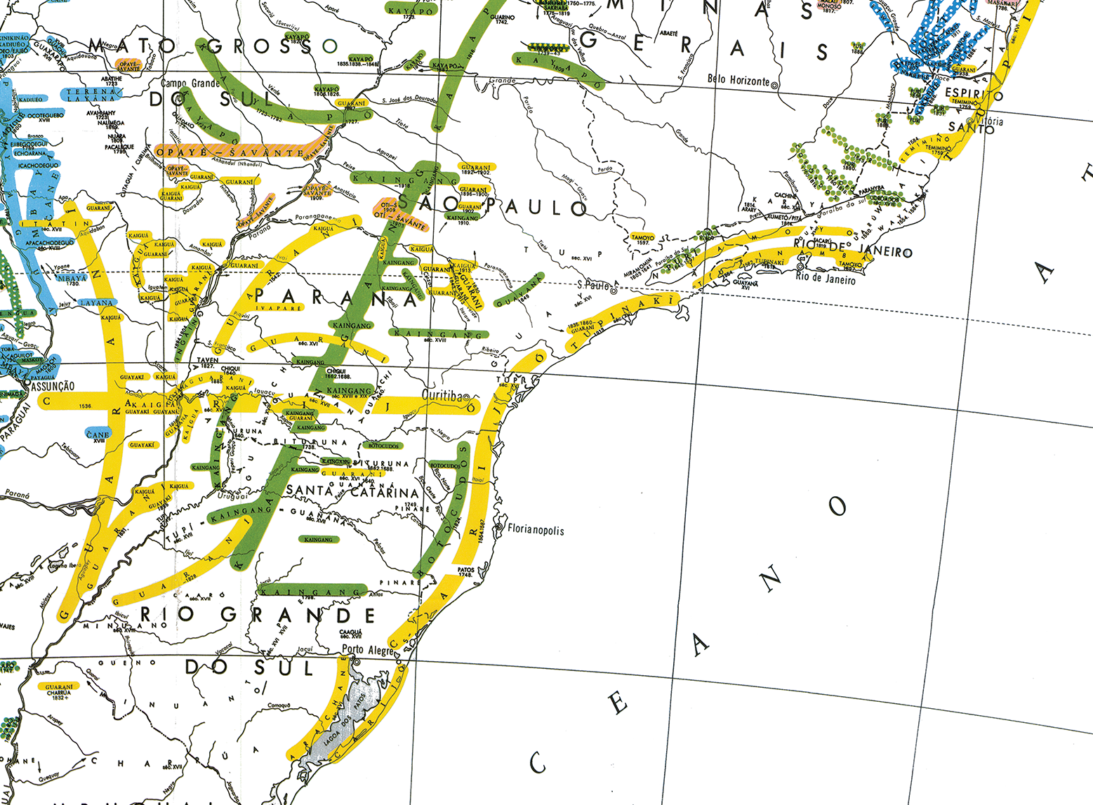
Conforme mostra o Mapa Etno-Histórico elaborado pelo etnólogo Curt Nimuendajú (1944), o território ancestral Guarani se estende desde a fronteira do estado do Paraná com o Paraguai, a Argentina e a Bolívia, até o estado do Espírito Santo, passando por Mato Grosso do Sul, São Paulo e Rio de Janeiro. Também existem terras Guarani nos estados de Tocantins e Pará. Os ancestrais Guarani caminhavam, e os Guarani de hoje seguem caminhando, por todo o território, que chamam de Yvyrupa, “o leito da terra”, nas palavras do professor Jurandir Tupã Jekupe Mirim.
Com a invasão Europeia, assim como aconteceu em outros territórios indígenas, os territórios Guarani foram brutalmente reconfigurados por deslocamentos forçados e extermínios.
Em São Paulo, após a criação do aldeamento do Pateo do Collegio em 1554, as populações tupi-guarani que habitavam a região foram submetidas a sistemáticas políticas de confinamento e escravização.
Marco fundante da cidade, o Pateo do Collegio irradiou a colonização sobre o Jaraguá, uma das primeiras regiões onde os europeus exploraram ouro no Brasil Colônia. O Jaraguá passa então a ser alvo da exploração de bandeirantes, e assim é continuamente despovoado de seus habitantes nativos.
Em 1554 funda-se o povoado de São Paulo dos Campos de Piratininga, futura cidade de São Paulo, onde hoje encontra-se o Pateo do Collegio.
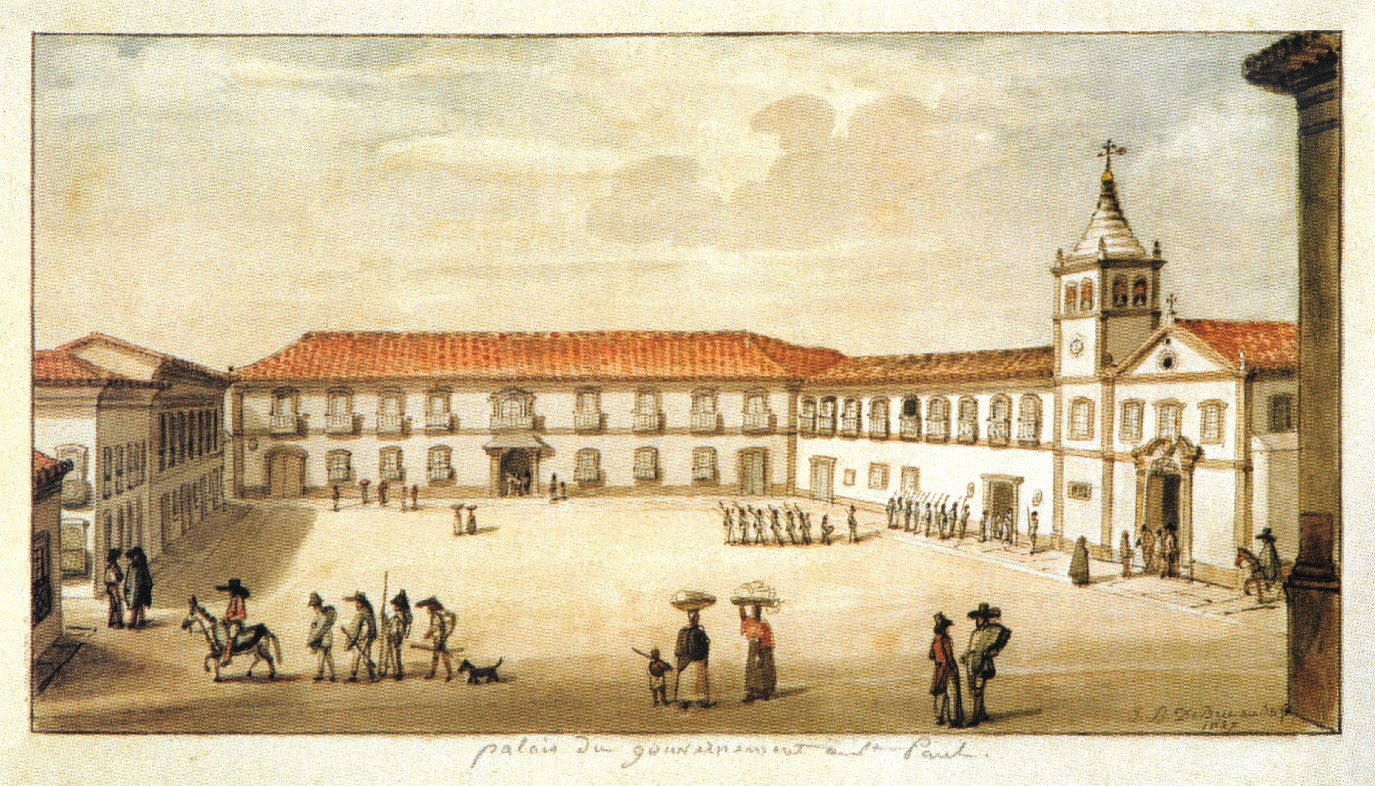
Em 1560, ao sul do Pico do Jaraguá, na região de Barueri, José de Anchieta mandou erguer outro aldeamento para concentração e catequização dos indígenas.
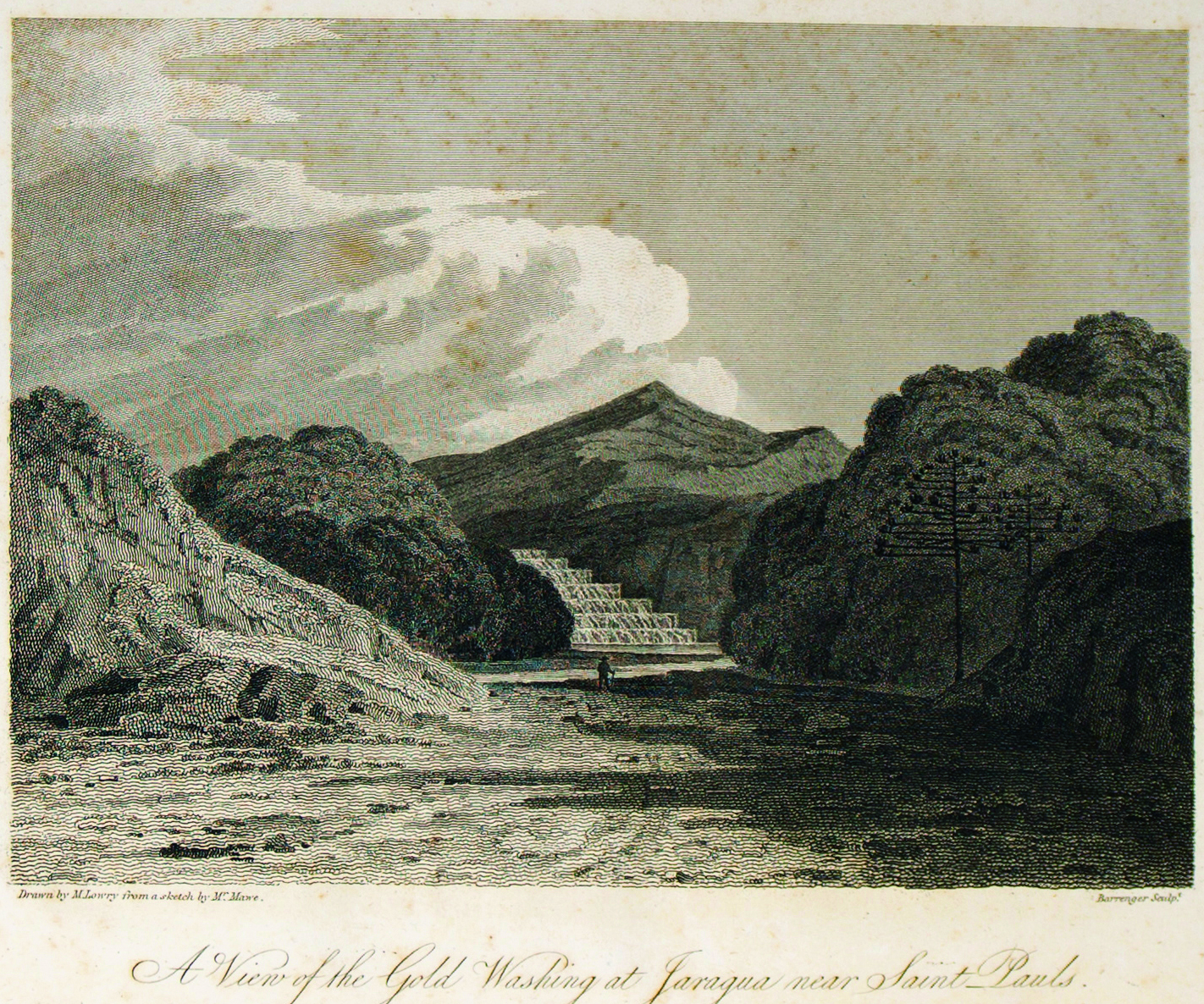
Pouco depois, em 1597, o bandeirante Afonso Sardinha encontra ouro na região do Jaraguá. Estabelece uma grande propriedade na área com a construção de um complexo Casa Grande – Senzala ao pé do morro.

Com a exaustão do ouro em São Paulo e a descoberta das minas em Goiás e Minas Gerais, a área do Pico do Jaraguá transforma-se numa enorme propriedade agrícola. Durante o século XIX, seguindo a expansão da economia cafeeira paulista, a chamada “Fazenda Jaraguá” torna-se uma grande produtora de café, e vastas áreas de Mata Atlântica são arrasadas.
Espécies de café remanescentes destas plantações são encontradas até hoje por toda a Terra Indígena Jaraguá.
A CRIAÇÃO DO PARQUE DO JARAGUÁ
Na década de 1940, com o declínio da atividade cafeeira, a Fazenda Jaraguá é adquirida pelo município de São Paulo e torna-se propriedade estatal. Em 1946, a propriedade passa a ser administrada pelo Serviço Florestal do município.
Por esta época, na primeira metade do século XX, o Jaraguá continuava sendo um lugar habitado pelos Guarani através dos caminhos que conectavam o Paraná e o Mato Grosso do Sul até o Vale do Ribeira e o litoral paulista.
Em 1961, no contexto do estabelecimento das primeiras reservas florestais nacionais, cria-se o Parque Estadual do Jaraguá, que pela primeira vez garante algum nível de proteção ambiental aos remanescentes de Mata Atlântica no Pico do Jaraguá.
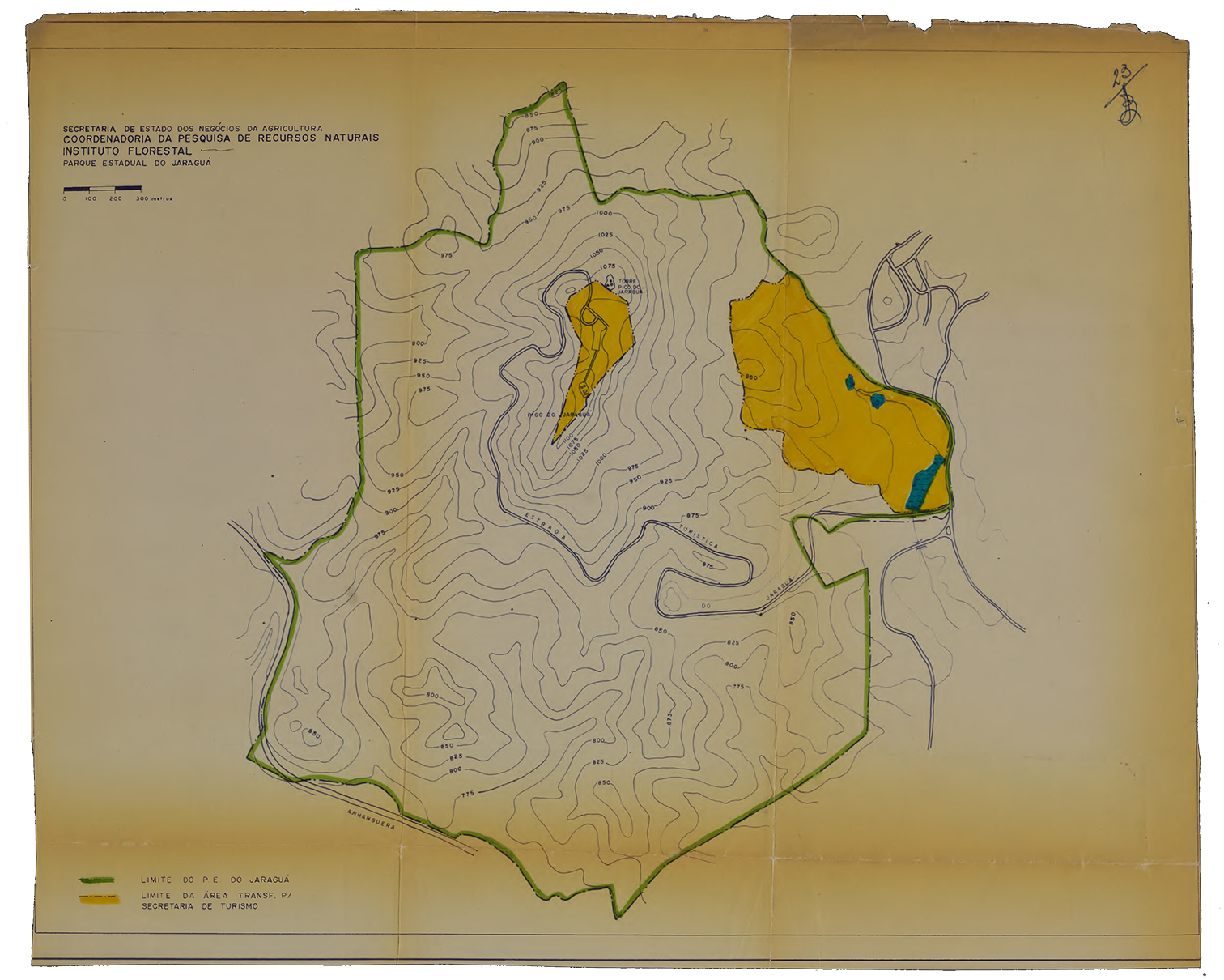
Ao proteger as florestas do Jaraguá dentro dos parâmetros ambientalistas tradicionais, o Parque Estadual acabou não apenas cerceando o uso das matas pelas comunidades Guarani, mas também foi um modo de apagar a presença indígena da região, definindo a área como uma grande reserva ecológica homogênea, vazia e inabitada .
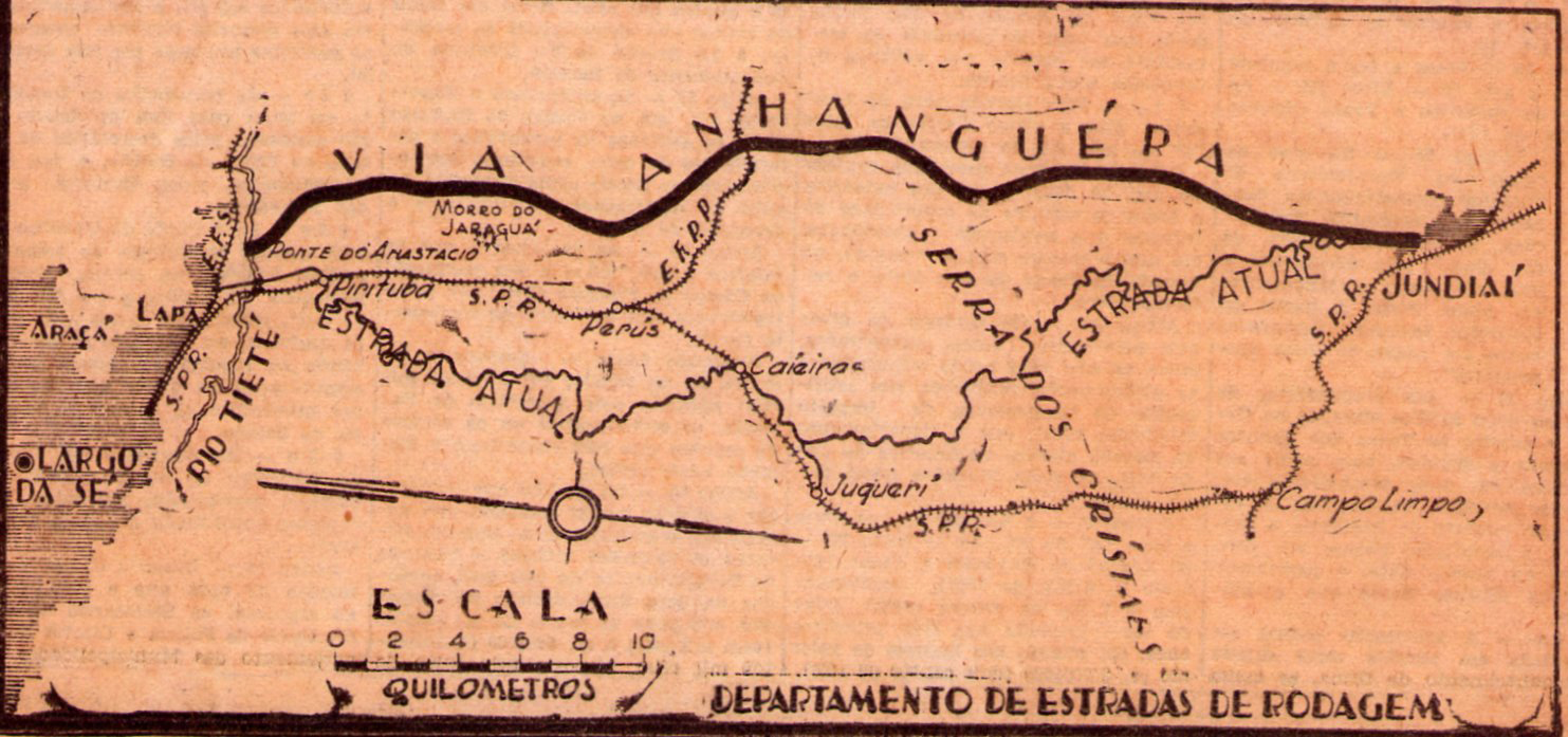
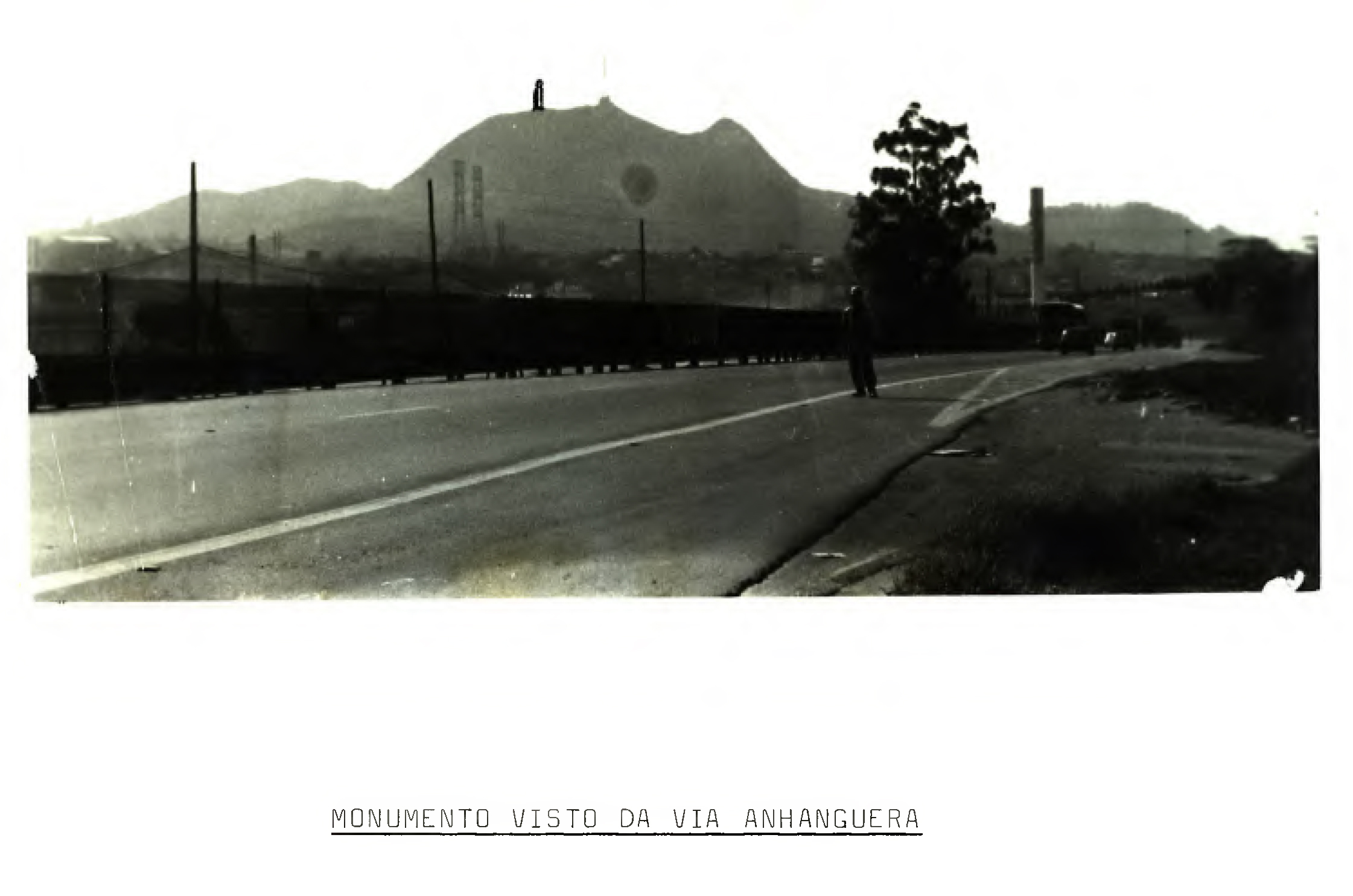
Em paralelo, São Paulo vive um rápido processo de urbanização. Entre 1940 e 1948 é construída a rodovia Anhanguera nas margens do Território Guarani do Jaraguá, e em 1955 é construído o linhão de transmissão Anhangabaú-Jundiaí sobre o pico do morro. Estas grandes infraestruturas de transporte e energia inter-urbanas abrem caminho para a voraz especulação imobiliária que se daria nas décadas seguintes, principalmente com o regime militar depois do golpe de 1964.
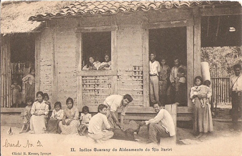
No arco do século XIX ao início do século XX, ocorrem grandes migrações Guarani da região fronteiriça do Paraná e do Mato Grosso do Sul para o estado de São Paulo.
Como identificado por Curt Nimuendajú, nos anos 1810, 1820 e 1870, e possivelmente em outros períodos do século XIX, registram-se migrações de grupos Guarani vindos da região do Iguatemi, na fronteira entre o Paraná e o Mato Grosso. Em 1910, sabe-se da migração de outro grande grupo Guarani vindo da região fronteiriça Brasil-Paraguai-Argentina para a região de Itariri no Vale do Ribeira, atual Terra Indígena Itariri. Entre 1923 e 1946 registram-se sucessivas migrações de grupos Guarani vindos do sul do Brasil para o estado de São Paulo, assentando-se principalmente no litoral (fonte).
Estes últimos grupos formam a geração imediatamente anterior de vários moradores das T.I.s Jaraguá e Tenondé Porã na cidade de São Paulo. Entre eles está a cacica Jandira, fundadora da Tekoa Ytu no início dos anos 1960, primeira tekoa da retomada do Jaraguá.
Após a criação do Serviço de Proteção aos Índios (SPI) em 1910, os povos Guarani são alvo de uma política sistemática de aldeamentos. No estado de São Paulo, o SPI busca concentrar as famílias Guarani no Posto Indígena do Bananal em Itanhaém, no litoral, e no Posto Indígena de Araribá, no interior, despovoando a cidade de São Paulo da presença Guarani.
Com sua resistência ancestral, fugindo dos aldeamentos, algumas famílias iniciam retomadas na cidade de São Paulo no Jaraguá e na região de Parelheiros, atuais Terra Indígena Jaraguá e Terra Indígena Tenondé Porã.
Seguindo a lógica desenvolvimentista dos anos 1960 e 1970, o período da ditadura militar é marcado por investimentos em mega infraestruturas e pelo planejamento autoritário.
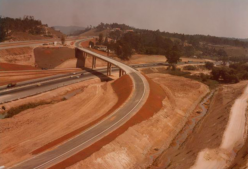
Na cidade de São Paulo, realizam-se grandes obras urbanas e rodoviárias, como a Rodovia dos Bandeirantes, que atinge diretamente o território ancestral Guarani do Jaraguá. O Pico do Jaraguá é designado para receber torres de antenas de comunicação, e são concedidas terras para o Grupo Bandeirantes, a TV Globo, a Fundação Padre Anchieta (TV Cultura) e o Exército. Em 1972 é construído um grande complexo turístico no parque.
Na esteira destas obras, a especulação imobiliária e a urbanização expandem-se vertiginosamente nas margens de São Paulo, avançando sobre as florestas do Jaraguá. As décadas entre 1960 e 1980 registram altos índices de desmatamento na franja da zona norte da cidade, com o adensamento de bairros como Jaraguá e Pirituba.
Ao passo que os “grandes empreendimentos” da ditadura militar avançavam Brasil afora, os povos indígenas eram reprimidos pelo regime e seus direitos sistematicamente violados.
Como mostra o relatório da Comissão Nacional da Verdade, no contexto dos planos de desenvolvimento nacional, inúmeras comunidades indígenas foram submetidas a transferências e remoções forçadas executadas por agentes de estado para abrir terras para obras de infraestrutura.
É o caso da construção da Usina Hidrelétrica de Itaipu no centro do território ancestral Guarani no Oeste do Paraná. O imenso lago artificial de Itaipu inundou dezenas de tekoas, e várias famílias Guarani foram forçadas a deixar suas terras, algumas migrando para São Paulo.
Ao mesmo tempo, lideranças indígenas eram perseguidas pelo Estado por seu ativismo político pela defesa dos territórios, ou tornavam-se alvo de milícias ruralistas, como no caso do grande líder guarani-ñadeva Marçal de Souza. Um dos precursores das lutas guarani pela recuperação e reconhecimento de seus territórios ancestrais, Marçal de Souza, Tupã-Y, foi assassinado por pistoleiros no Mato Grosso do Sul em novembro de 1983.
A resistência dos povos indígenas desempenhou um papel protagonista na derrocada do regime militar e no retorno à democracia nos anos 1980.
Sob pressão do movimento indígena, a Constituição de 1988 reconhece o direito dos povos originários a seus territórios ancestrais, sendo esses direitos anteriores à própria criação do Estado brasileiro. A Constituição também garante a proteção da organização social, costumes, línguas, crenças e tradições dos povos indígenas.
Neste contexto, assim como outros territórios e movimentos populares, o Jaraguá passa por um processo de crescente organização política e reclame de direitos.
Pressionada pelo movimento indígena, em 1984 – ano do movimento “Diretas Já” – a FUNAI procede com regularização de algumas terras indígenas no Estado de São Paulo, incluindo uma pequena parte da Terra Indígena Jaraguá correspondente à Tekoa Ytu, demarcada em 1987.
Ainda que representassem avanços democráticos, estas demarcações eram claramente insuficientes, especialmente no caso da TI Jaraguá, onde a área demarcada abrangia apenas o perímetro de 1.8 hectares do núcleo habitacional da Tekoa Ytu. Deste modo, a demarcação ignorava a extensão territorial do uso tradicional das matas que mantém o nhandereko, o modo de habitar Guarani.
Em paralelo, no arco entre os assassinatos de Marçal de Souza e Chico Mendes em 1983-1984, e a realização do encontro internacional ECO-92 promovido pelas Nações Unidas no Rio de Janeiro em 1992, a pauta ambiental consolida-se internacionalmente e no Brasil.
Em 1994 o Parque Estadual do Jaraguá é reconhecido pela UNESCO como Patrimônio da Humanidade, na categoria de Reserva da Biosfera, passando a integrar o Cinturão Verde da Cidade de São Paulo.
Assim como na criação do Parque Estadual em 1961, tais medidas protetivas ambientalistas muitas vezes entram em conflito com o direito das comunidades Guarani ao seu território ancestral, impedindo-as de usufruir dos recursos naturais das florestas dentro do perímetro do Parque, que hoje encontra-se totalmente cercado.
Em 2013, a FUNAI finalmente realiza o estudo de demarcação da T.I. Jaraguá – o chamado “Relatório Circunstanciado de Identificação e Delimitação” ou “RCID” – que identifica uma área de uso tradicional de 532 hectares.
Dois anos depois, em 2015, sob pressão dos grandes protestos realizados por ativistas Guarani em São Paulo, o governo de Dilma Rousseff (Portaria 581) reconhece a posse indígena permanente do Jaraguá, um momento histórico celebrado por toda Yvyrupa.

Mas a justiça ao reconhecimento da posse ancestral Guarani do Jaraguá teve vida curta. Eventos políticos em Brasília trazem uma reviravolta ao processo.
Em 2017, após o impeachment de Dilma Rousseff, o governo de Michel Temer anula a demarcação da Terra Indígena Jaraguá (Portaria 683). Ato contínuo, durante o governo de Jair Bolsonaro entre 2019 e 2022, o projeto da chamada “Lei do Marco Temporal”, que havia sido praticamente arquivado em 2018, volta a ser pauta no Congresso Nacional.
Em maio de 2023 a Câmara dos Deputados aprova a “Lei do Marco Temporal”. Cinco meses depois, em setembro de 2023, o Supremo Tribunal Federal rejeita a tese como inconstitucional. Entretanto, a proposta segue em pauta no Congresso Nacional até os dias de hoje, ameaçando a integridade dos territórios indígenas.
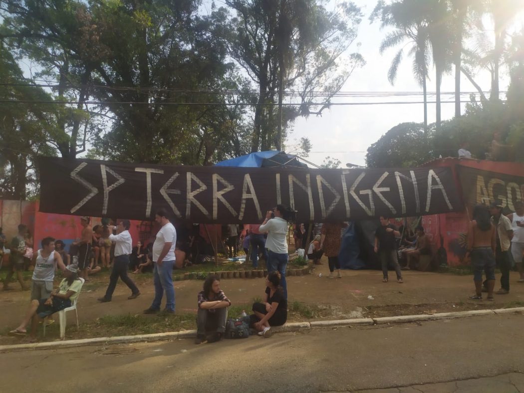
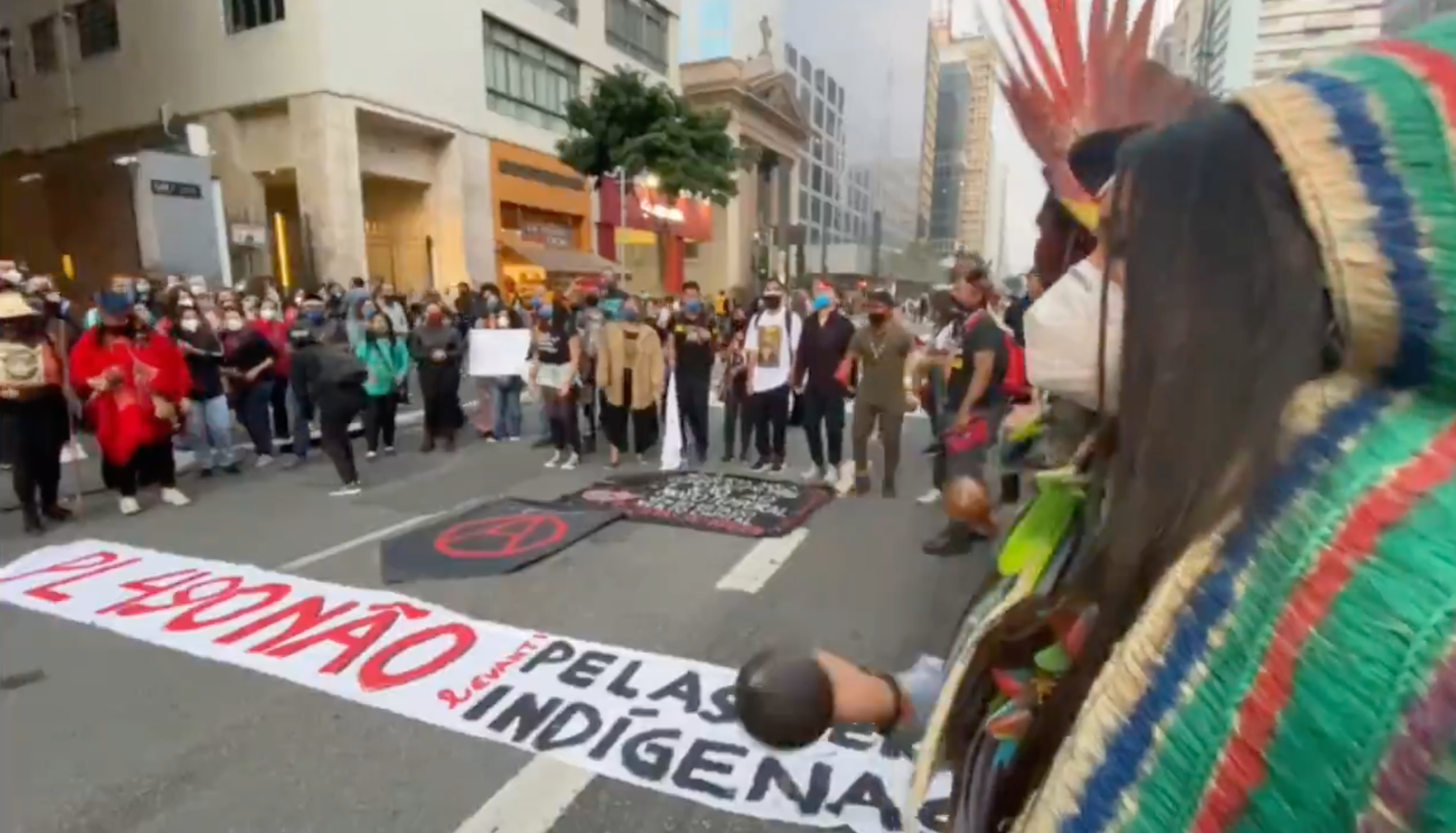
Em resposta a estas violações de seus direitos consagrados com a Constituição de 1988, entre 2013 e 2025, as comunidades Guarani do Jaraguá, junto com as comunidades de Tenondé Porã, realizam uma série de atos políticos e ações de advocacia, literalmente reocupando a cidade de São Paulo – Terra Indígena – durante uma década de sucessivas manifestações de grande amplitude política e cultural para a cidade e para todo o país.
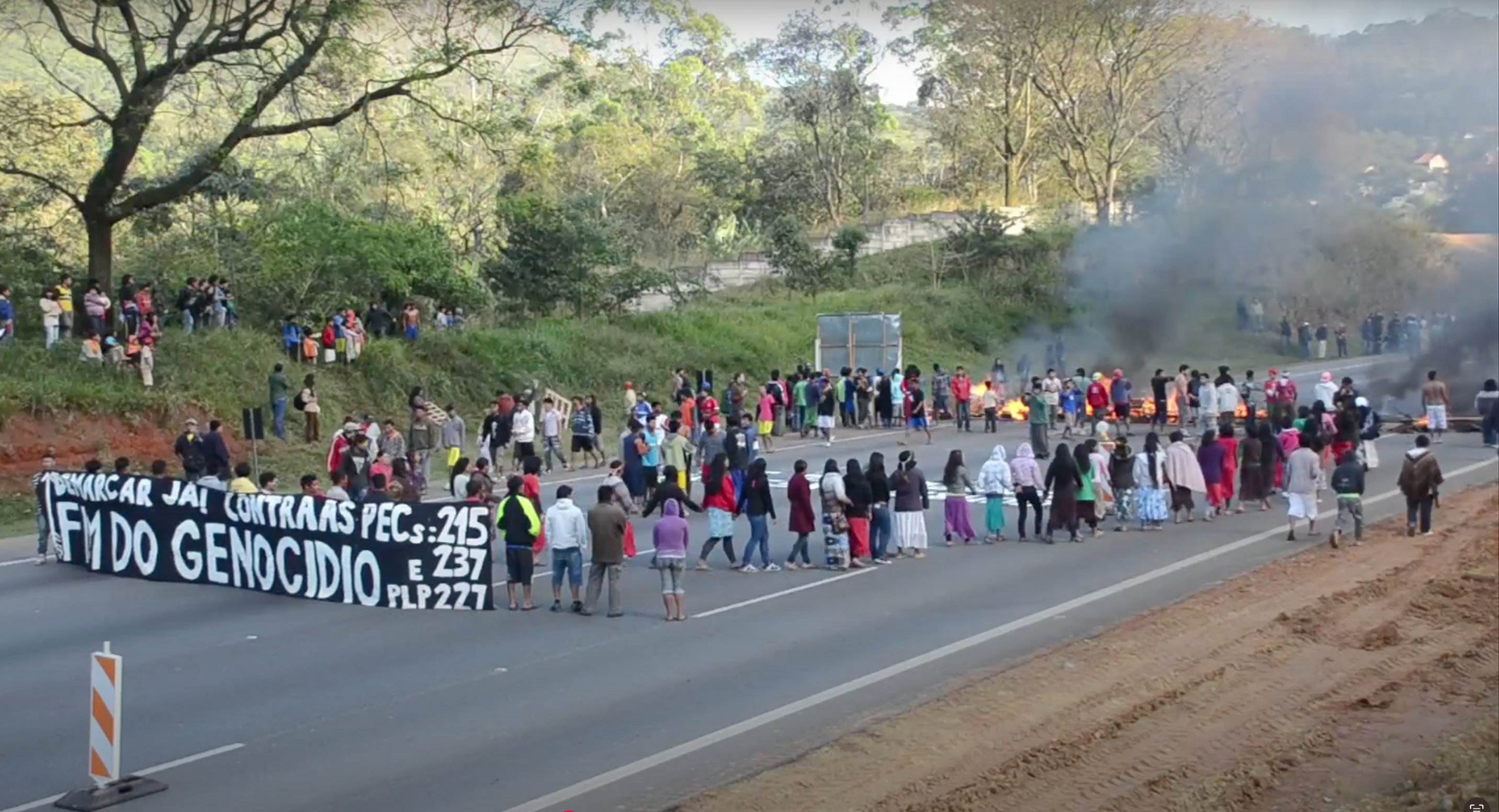
26 de setembro de 2013: Em protesto contra a Proposta de Emenda a Constituição 215/2000, que visava transferir do Poder Executivo para o Congresso Nacional a competência para a demarcação de terras indígenas e quilombolas, ativistas Guarani bloqueiam a Rodovia dos Bandeirantes. O protesto também pede a demarcação das T.I.s Jaraguá e Tenondé Porã
01 de outubro de 2013: Em uma caminhada da Avenida Paulista até o Monumento às Bandeiras, ativistas Guarani realizam “Ato de Defesa dos Direitos Indígenas e da Constituição Federal” contra a PEC 215
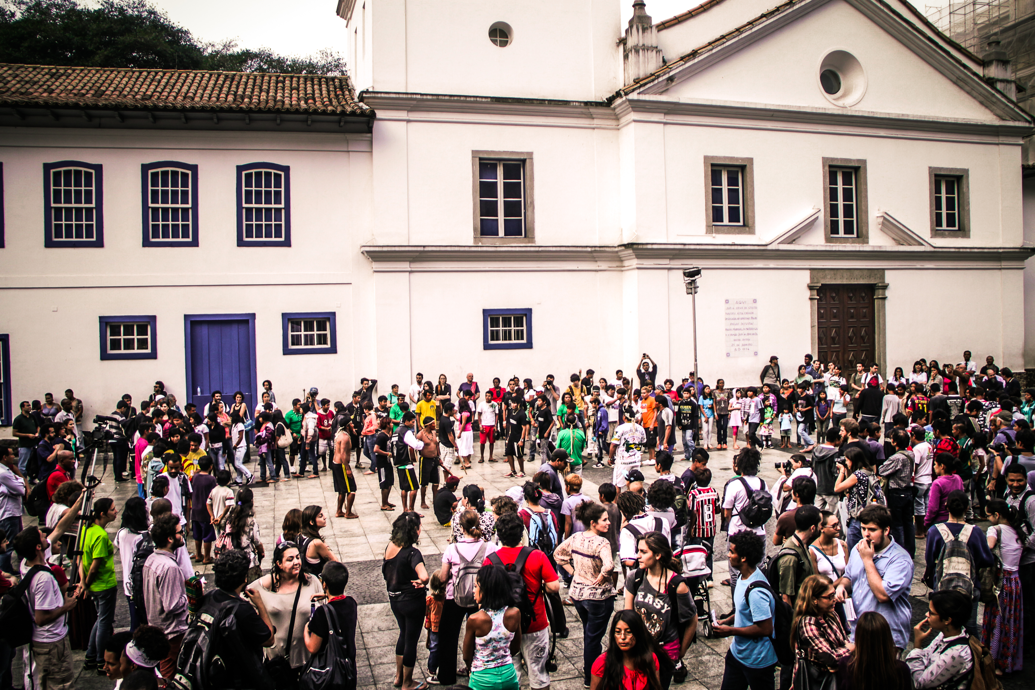
16 de abril de 2014: lançamento da campanha “Resistencia Guarani SP” com ato no Pateo do Colégio e ocupação do Museu Anchieta
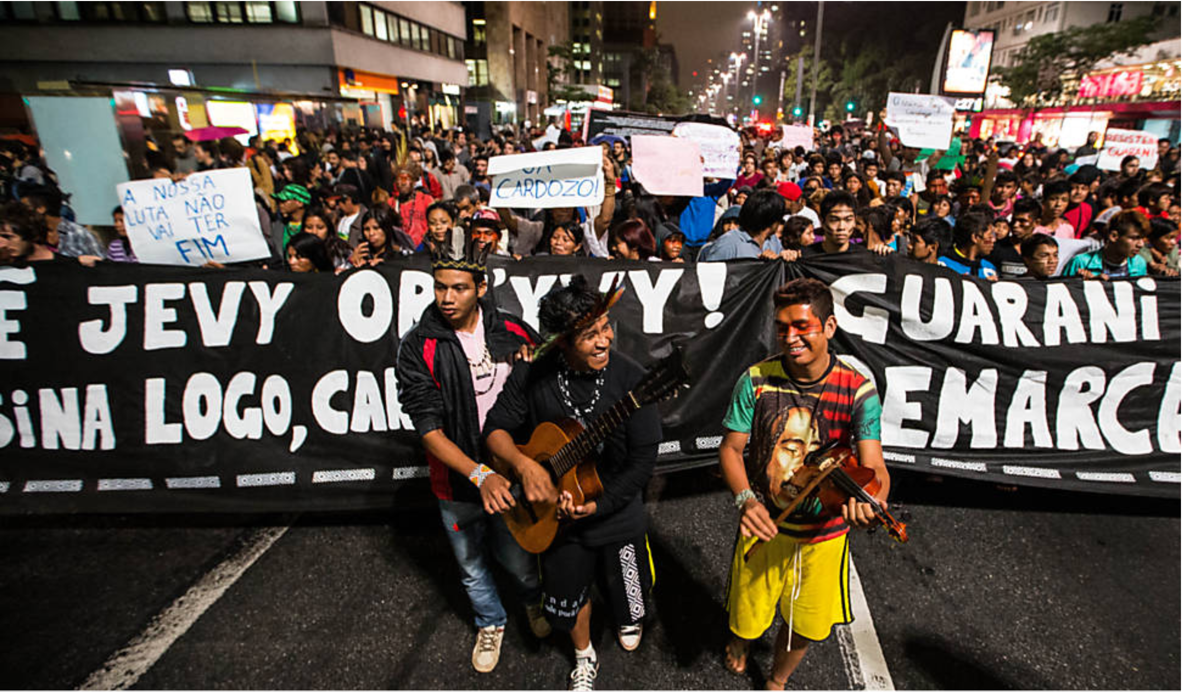
24 de abril de 2014: protesto partindo do MASP até a praça Roosevelt, exigindo a demarcação das T.I.s Jaraguá e Tenondé Porãa
06 de junho de 2014: protesto na Assembleia Legislativa de São Paulo e no Monumento às Bandeiras pelo arquivamento da PEC 215 e pela demarcação das T.I.s Jaraguá e Tenondé Porã
05 de maio de 2016: ativistas Guarani ocupam a sede da Secretaria da Presidência da República em São Paulo, na Avenida Paulista, em protesto pela demarcação das T.I.s Jaraguá e Tenondé Porã
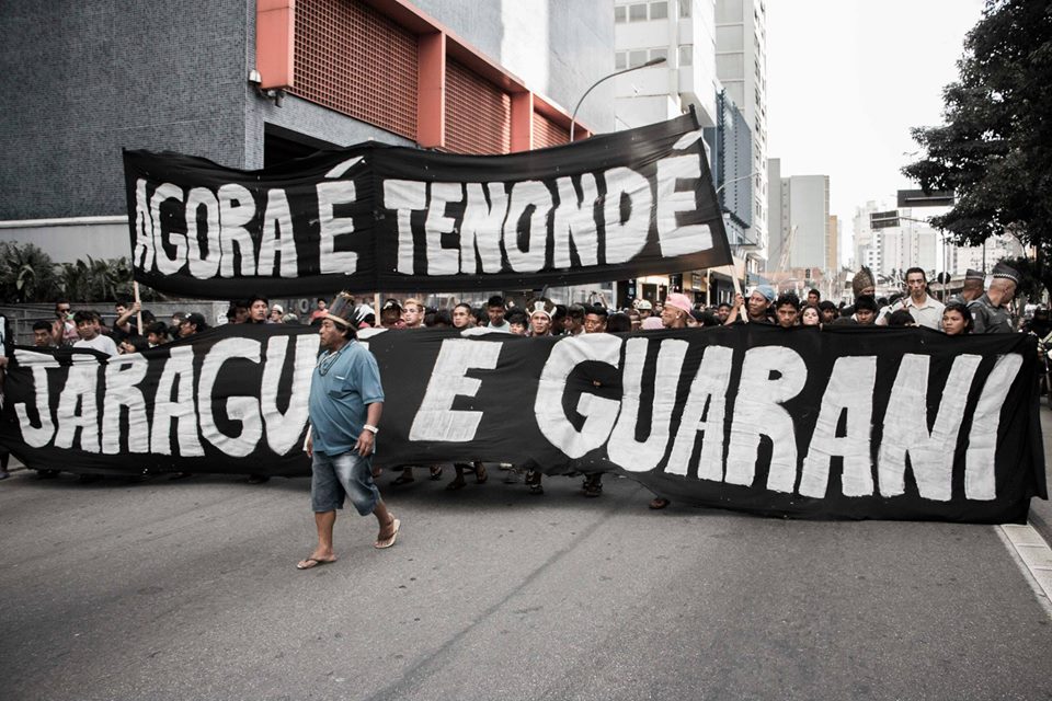
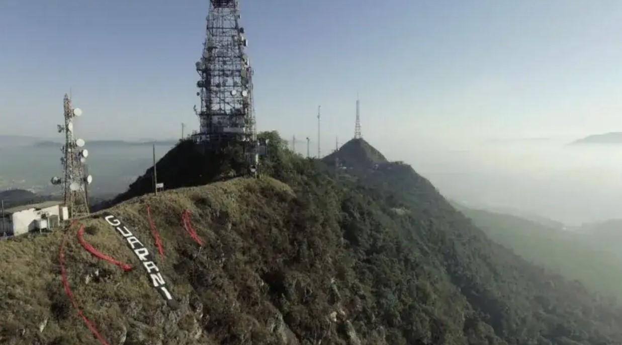
14 – 16 de setembro 2017: em protesto contra a anulação da demarcação da Terra Indígena Jaraguá pelo governo de Michel Temer, lideranças Guarani realizam uma série de protestos em São Paulo. No dia 30 de agosto, uma ampla mobilização toma a Avenida Paulista. Quinze dias depois, entre os dias 14 e 16 de setembro, ativistas Guarani ocupam o Pico do Jaraguá e desativam as torres transmissoras, cortando o sinal de telefonia e televisão para uma vasta região da cidade de São Paulo
Janeiro-Março de 2020: ativistas Guarani ocupam o terreno onde seria construído o condomínio residencial “Reserva Jaraguá-Carinás”, situado próximo à aldeia Pyau. Executado pela construtora Tenda, o empreendimento levou à derrubada de cerca de quatro mil árvores em uma área da Reserva da Biosfera do Cinturão Verde de São Paulo. Chamada de Yary Ty, a ocupação dura até o mês de março, quando é removida pela Polícia Militar
Junho de 2021: a volta da discussão sobre o Marco Temporal no Congresso Nacional desencadeia uma série de protestos de organizações indígenas. No dia 25 de junho, ativistas Guarani bloqueiam a Rodovia dos Bandeirantes. Cinco dias depois ocupam o Parque Estadual do Jaraguá e as antenas. Simultaneamente ocorrem manifestações na Avenida Paulista
03 de julho de 2021: no contexto da pandemia da COVID, ativistas Guarani participam da grande manifestação contra o governo do presidente Jair Bolsonaro, trazendo a pauta do Marco Temporal para a manifestação
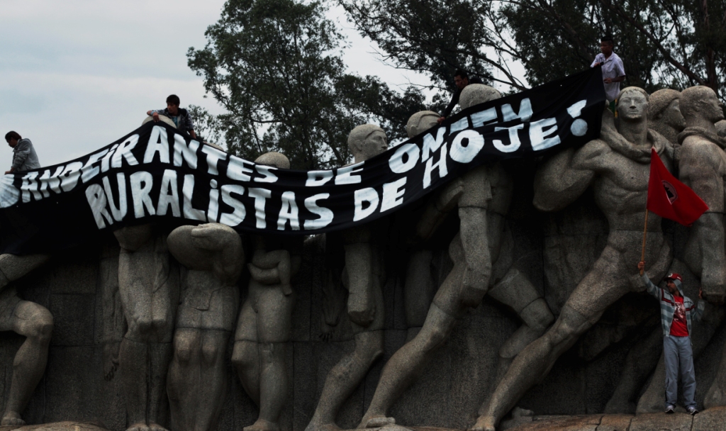
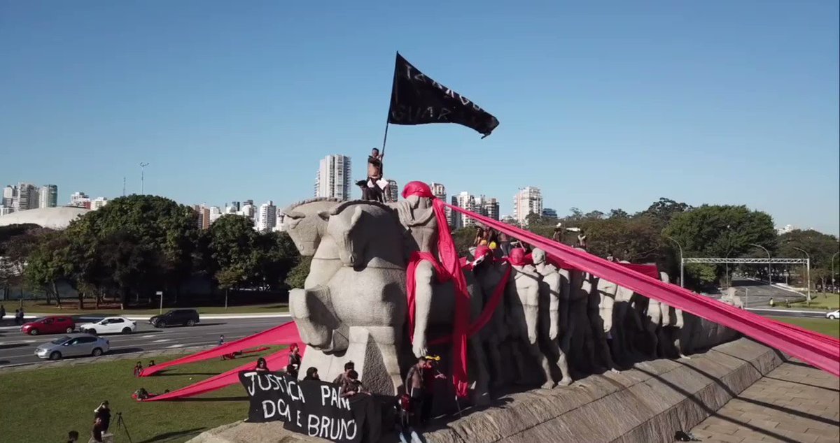
23 de junho de 2022: ocupação do Monumento às Bandeiras em protesto contra a tramitação da lei do Marco Temporal
09 de agosto de 2022: ato organizado pela Comissão Yvyrupa na Faculdade de Direito da USP, no Largo São Francisco, contra o Marco Temporal
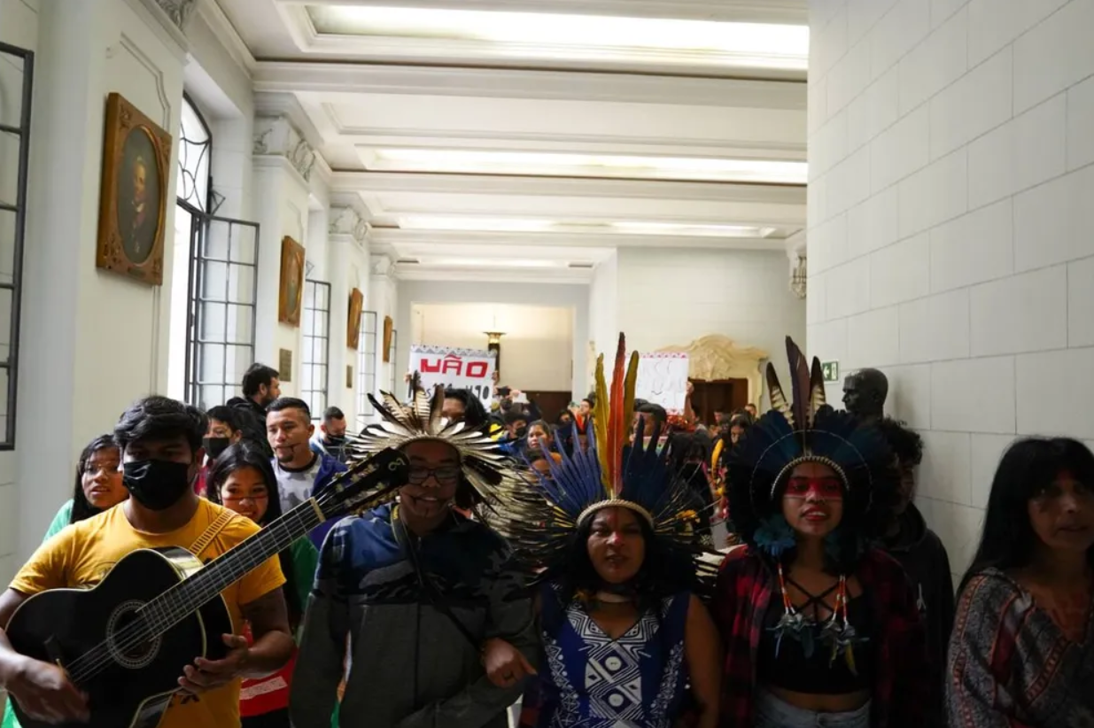
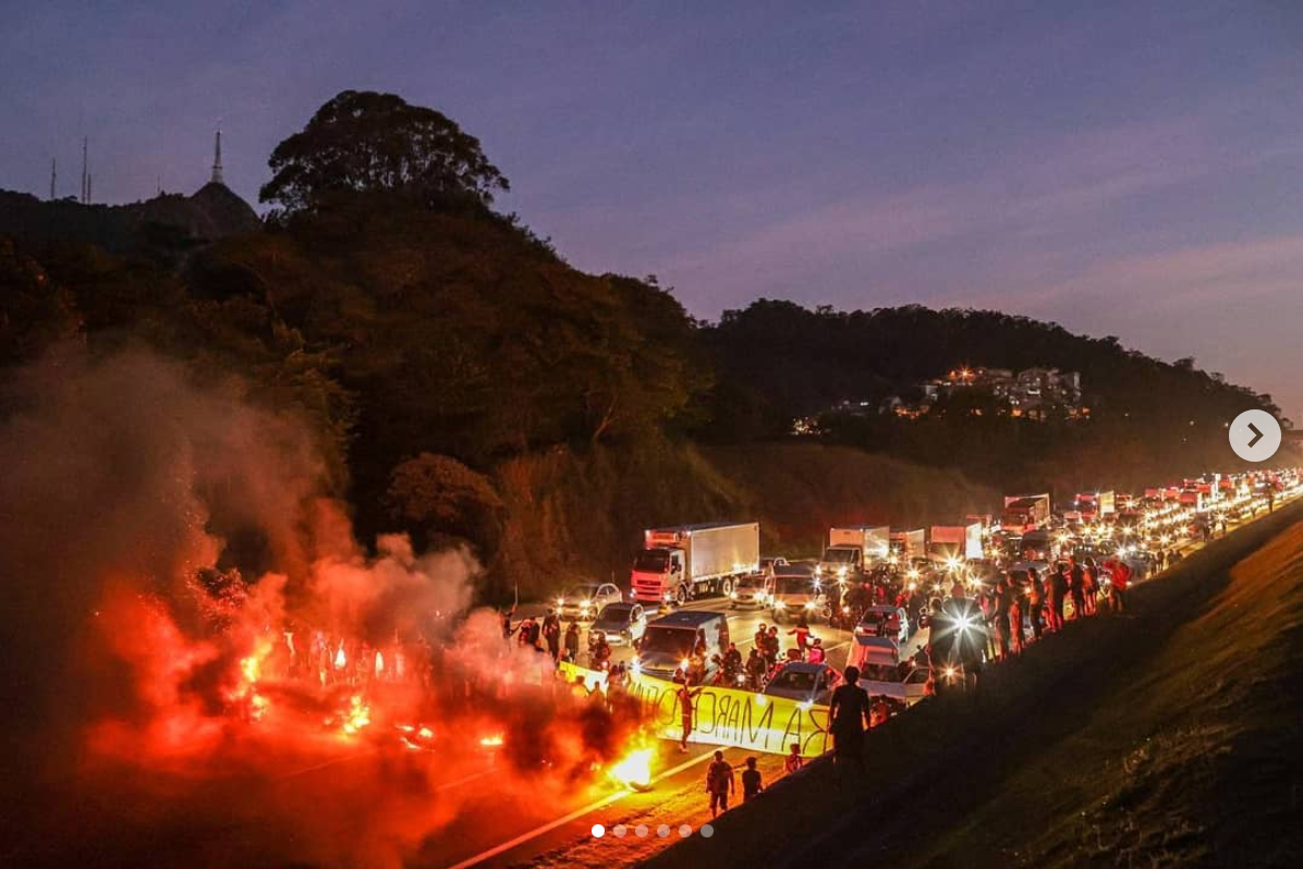
Maio-Junho de 2023: em protesto contra a aprovação da PL490/2007 pelos deputados em Brasília, ativistas Guarani novamente bloqueiam a Rodovia dos Bandeirantes. A manifestação é duramente reprimida pela Polícia Militar. Dias depois, em 04 de junho, a comunidade Guarani realiza a “Caminhada pela Vida” na área da T.I. Jaraguá

07 de junho de 2023: desafiando a repressão estatal, no dia 07 de junho ativistas Guarani realizam novo ato contra o Marco Temporal, desta vez na escadaria do Teatro Municipal no centro de São Paulo

Após a eleição de Luiz Inácio Lula da Silva em 2023, e a criação do Ministério dos Povos Indígenas, retoma-se o processo de demarcação do território Guarani do Jaraguá em São Paulo. Através da Portaria 793 de 23 de Outubro de 2024, o Ministério da Justiça declara a nulidade da Portaria 683 de 2015, restabelecendo os efeitos da Portaria 581 de 2015 que reconhece a posse Guarani e a demarcação da Terra Indígena Jaraguá
Desde a criação do Parque Estadual em 1961, e principalmente no pós-ditadura militar, o Pico do Jaraguá e suas matas tornaram-se objeto de diversas iniciativas de patrimonialização pelo estado e pelo município de São Paulo.
Esta parte do mapeamento identifica as áreas e bens que foram reconhecidos por órgãos governamentais como patrimônio e estão sob alguma lei de salvaguarda e proteção.
Em sua maioria são sítios associados ao período colonial, particularmente ao período dos aldeamentos e da extração mineral no Jaraguá.
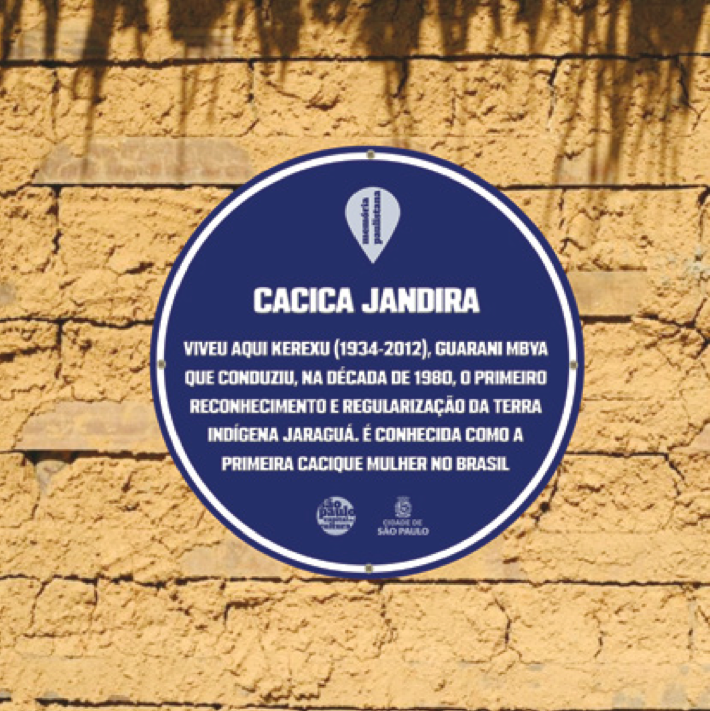
Apenas recentemente, em 2019, através do projeto “Memória Paulistana”, que dois lugares da memória Guarani entraram no inventário de lugares da memória da cidade de São Paulo: o lugar da casa da Cacica Jandira; e o ponto da Rodovia dos Bandeirantes onde ocorreram as manifestações históricas pela demarcação da TI Jaraguá.
PATRIMONIALIZAÇÃO DO JARAGUÁ
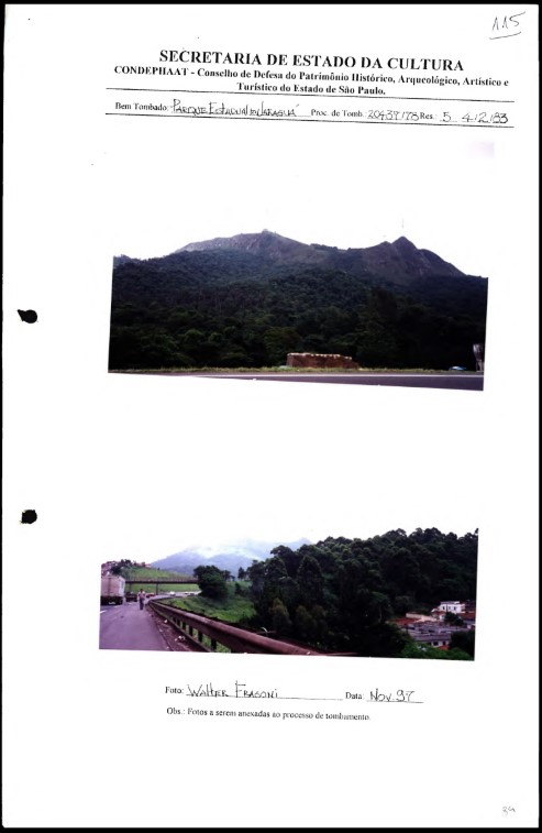
Em 1978, no contexto da construção do complexo turístico do Parque Estadual do Jaraguá, o conjunto Casa Grande-Senzala da propriedade do bandeirante Afonso Sardinha é tombado pelo CONDEPHAAT
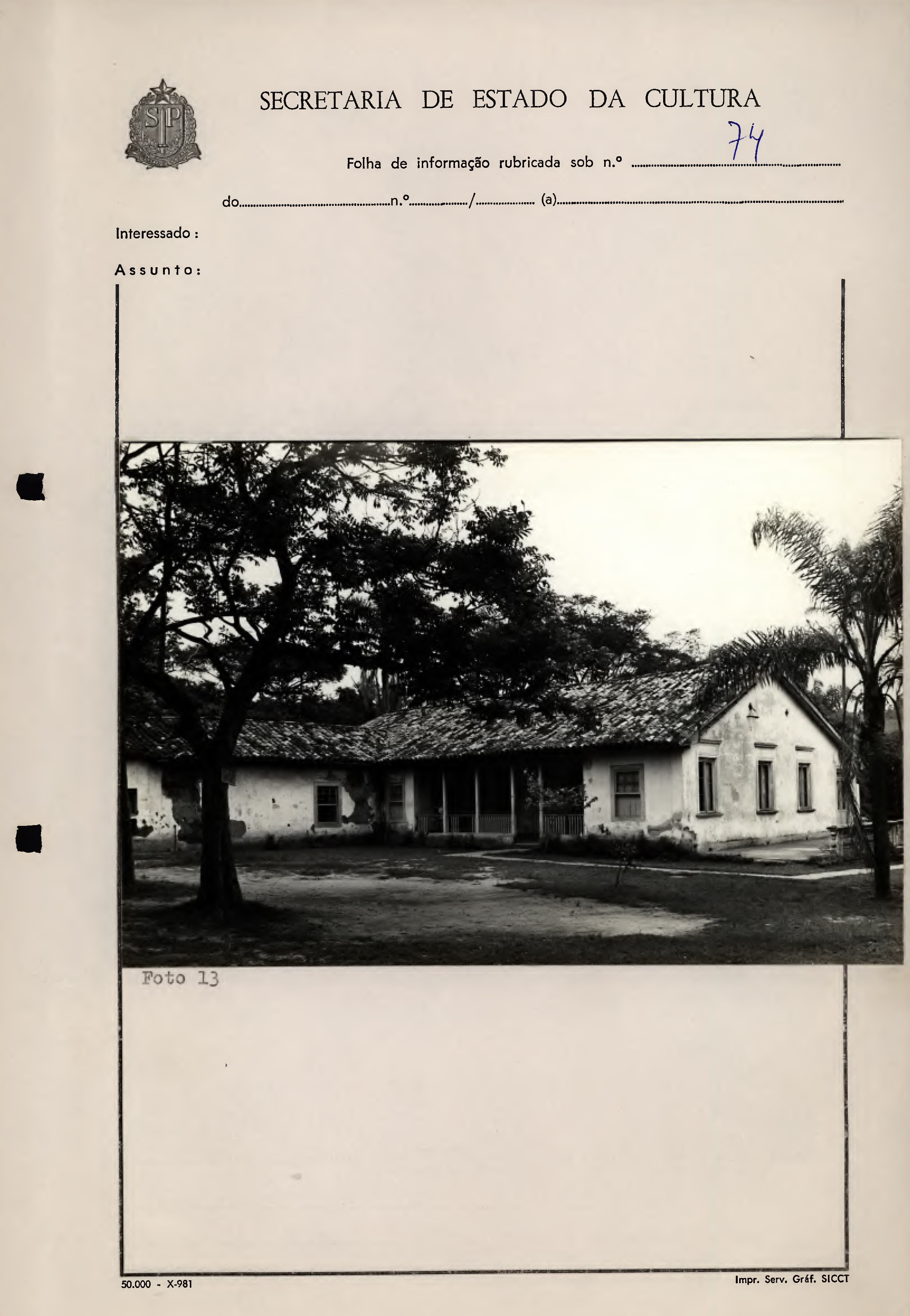
Em 1983, toda a área do Parque é tombada pelo CONDEPHAAT, e em 1992 pelo CONPRESP.
Em 2019 o CONPRESP tomba as estruturas remanescentes da Pedreira de Quartzito no Jaraguá, nas proximidades da Tekoa Itakupé.
Em 2019 o projeto “Memória Paulistana”, do Departamento de Patrimônio Histórico da Prefeitura de São Paulo, reconhece dois lugares de memória Guarani.
O lugar onde viveu a matriarca cacica Jandira, fundadora da Tekoa Ytu, a primeira retomada do Jaraguá; e o lugar onde foram realizados os protestos na Rodovia dos Bandeirantes.
O que se observa na trajetória de patrimonialização do Jaraguá é a ênfase dada pelos órgãos de salvaguarda de São Paulo no reconhecimento apenas do patrimônio colonial, buscando enfatizar uma narrativa bandeirante da origem e da identidade da cidade, narrativa esta que apaga a presença indígena.
Esse é o caso não apenas do patrimônio do Jaraguá mas de toda a cidade de São Paulo – Terra Indígena –, que através de monumentos como o Pateo do Colégio e o Monumento às Bandeiras constrói sua identidade sob o signo da conquista colonial.
Um dos exemplos mais emblemáticos desta narrativa colonialista oficializada pelos órgãos patrimoniais paulistas encontra-se no projeto de tombamento do Parque Estadual do Jaraguá, elaborado pelo CONDEPHAAT em 1978.
O projeto original propunha a criação de um complexo turístico no Parque do Jaraguá celebrando a memória da conquista colonial sobre as terras Guarani, com a construção de uma estátua-monumento gigante do jesuíta José de Anchieta, fundador do aldeamento do Pateo do Collegio, no topo do Pico do Jaraguá.
Assim como no monumento do Cristo Redentor no Rio de Janeiro, o projeto incluía a instalação de uma linha de bonde para levar os turistas até a grande estátua-monumento.
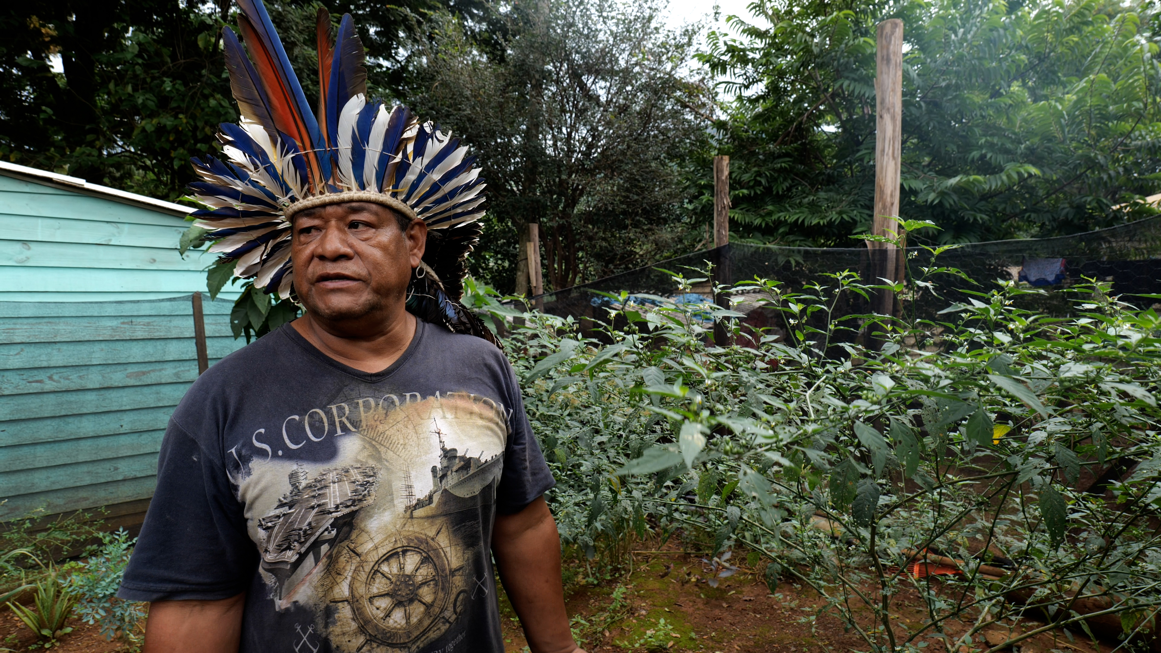
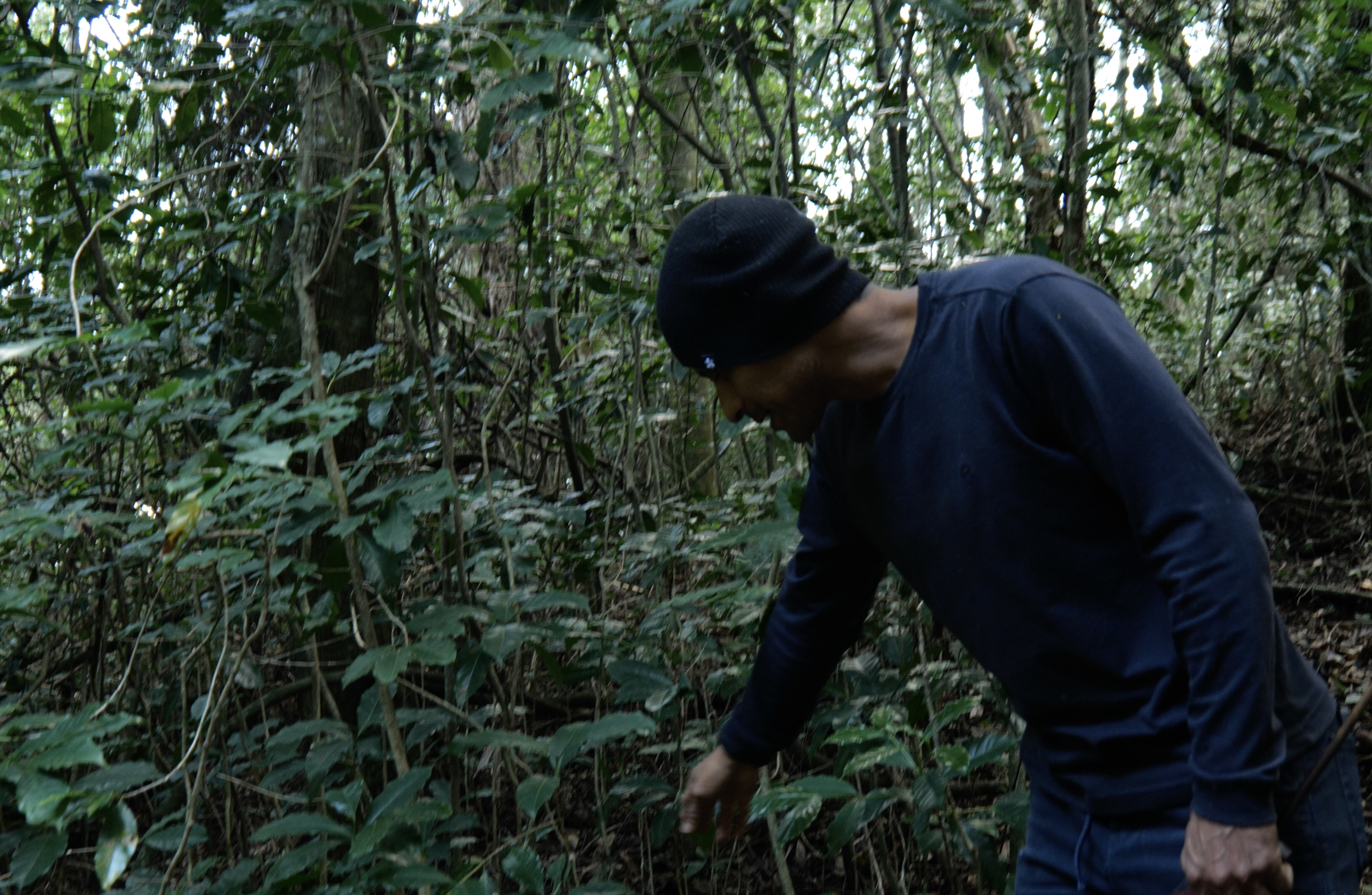
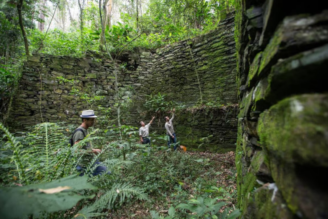
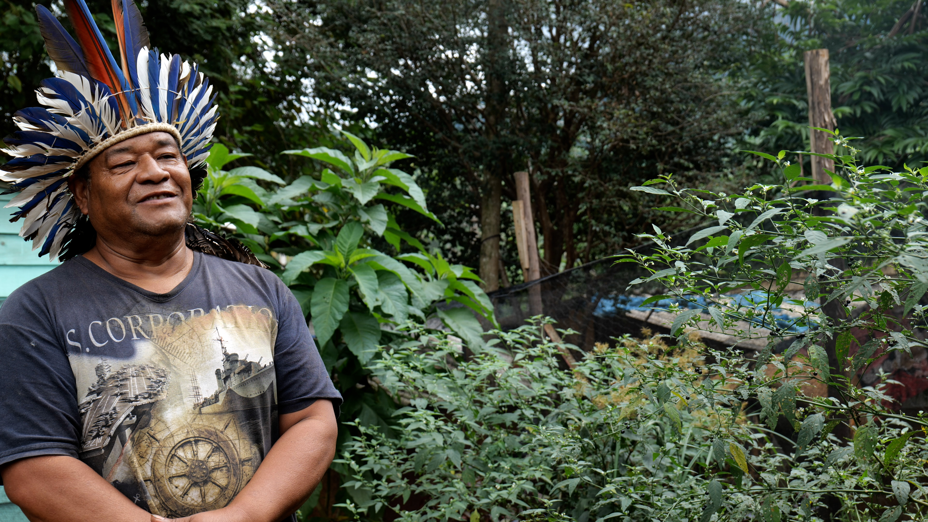
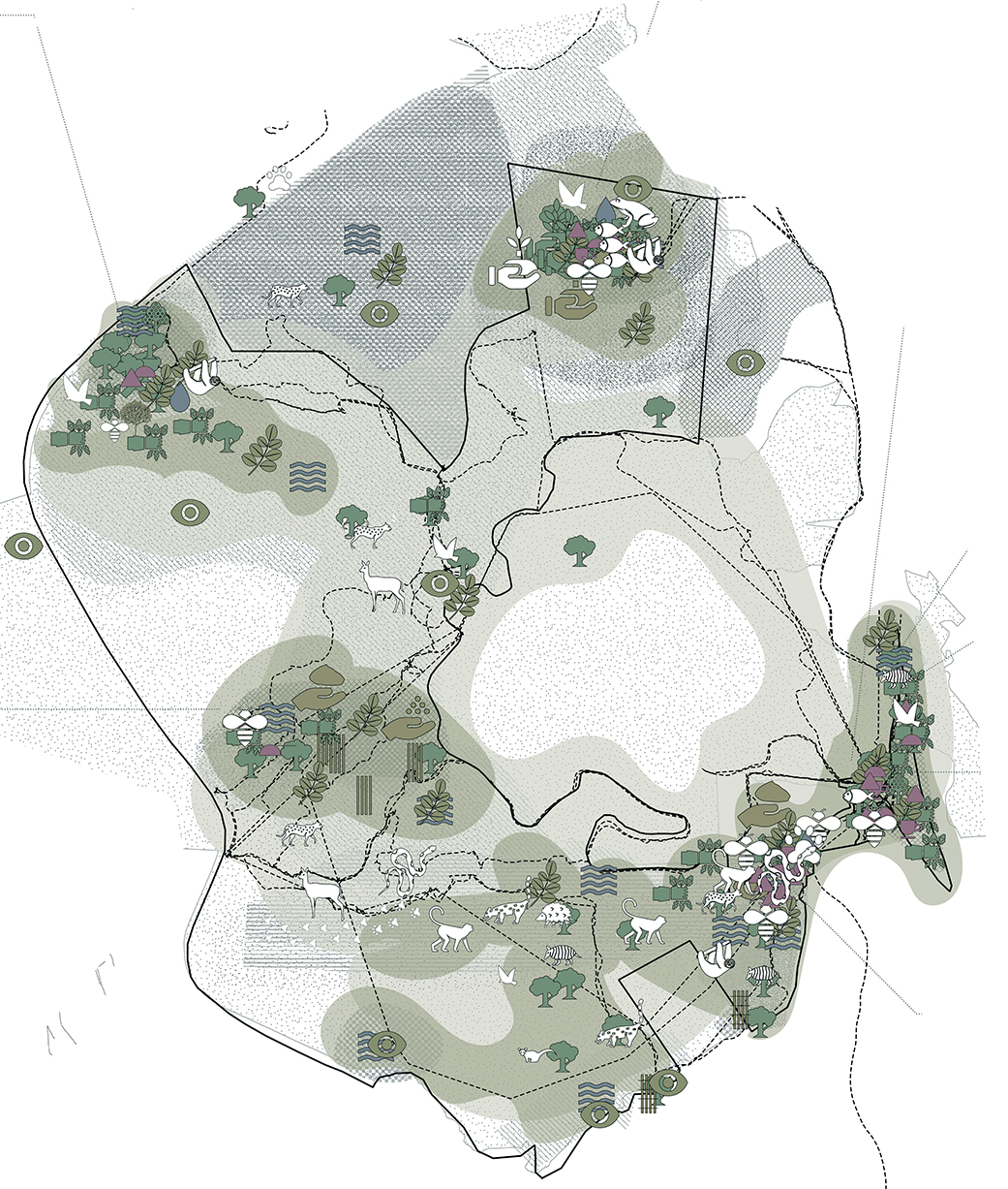
Por toda Yvyrupa, as retomadas de terras ancestrais dos povos Guarani carregam um sentido de reparar o território e a natureza. Ao longo dos mais de 75 anos de retomadas em São Paulo, as comunidades da TI Jaraguá estabeleceram várias práticas de cuidado, proteção e manutenção da biodiversidade em seu território.
Tekoas como Itawera, que recuperou uma grande área de lixão urbano, e Yvy Porã, com seu pioneiro projeto de recuperação de abelhas nativas, tornaram-se referência de restauração ambiental em tempos de urgência climática.
Em todos os núcleos habitacionais identificam-se práticas de recuperação e cuidado da mata, combatendo a poluição urbana da água e do solo, e promovendo o reflorestamento através do plantio de espécies nativas, o cultivo de roças tradicionais e jardins medicinais, e o monitoramento de animais silvestres.
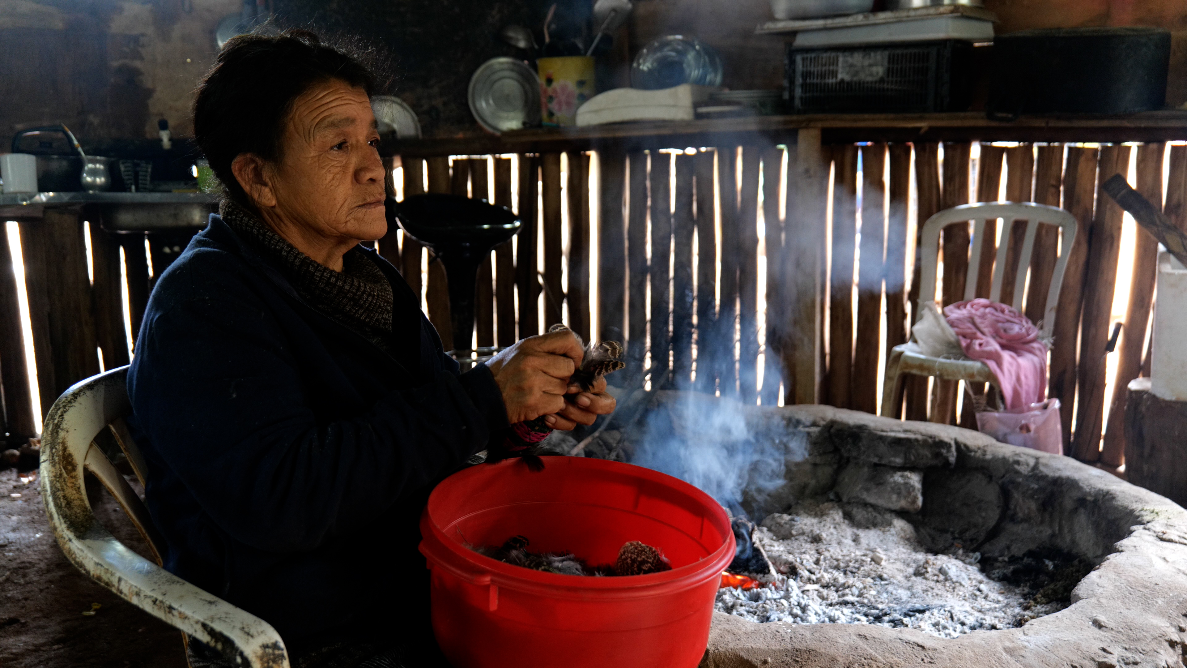
É a partir da contínua manutenção do _nhandereko, _o “modo de habitar” Guarani – saber ancestral transmitido pelos anciãos e anciãs – que tais práticas se constituem no tempo e no espaço através de gerações.
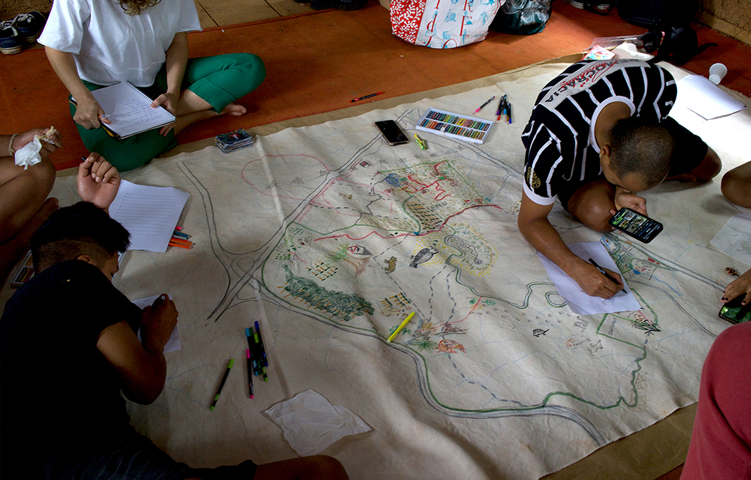
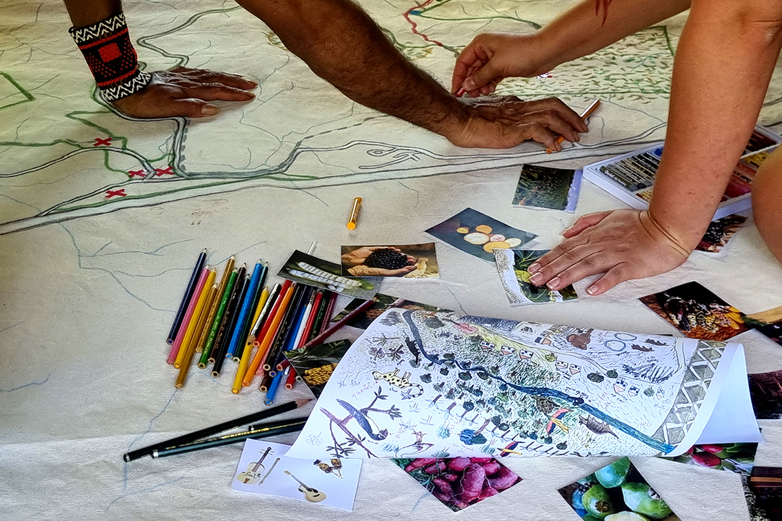
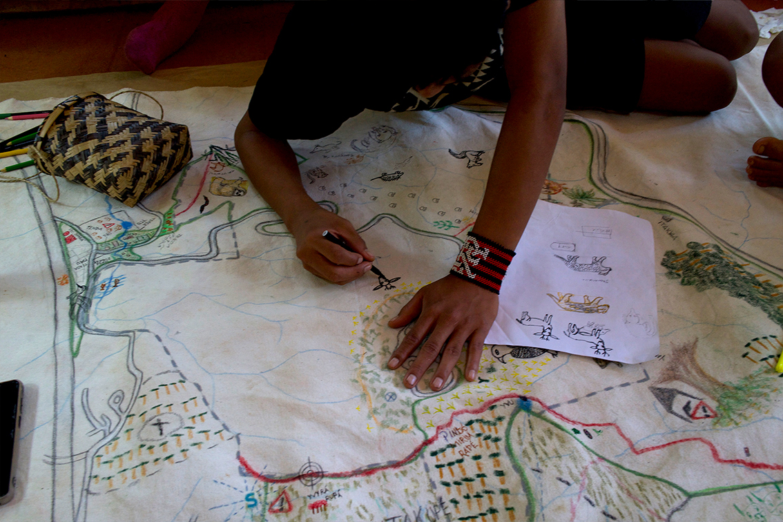
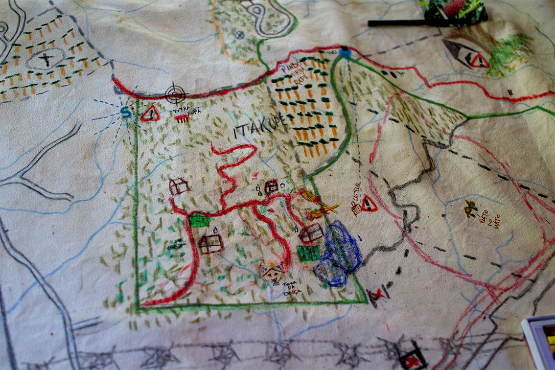
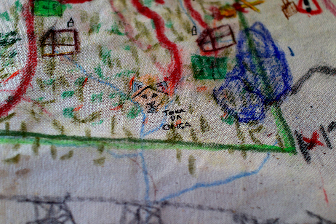
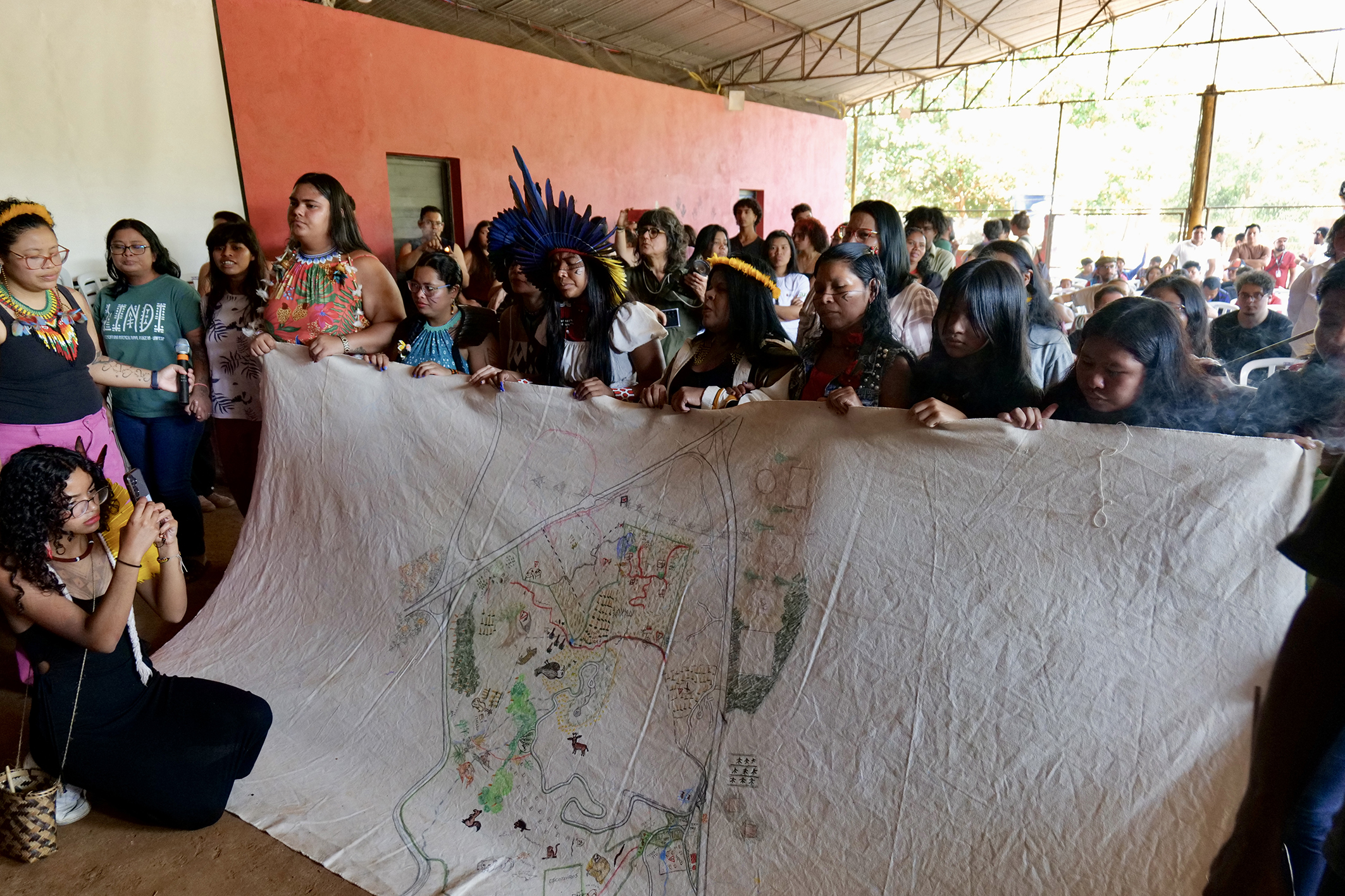
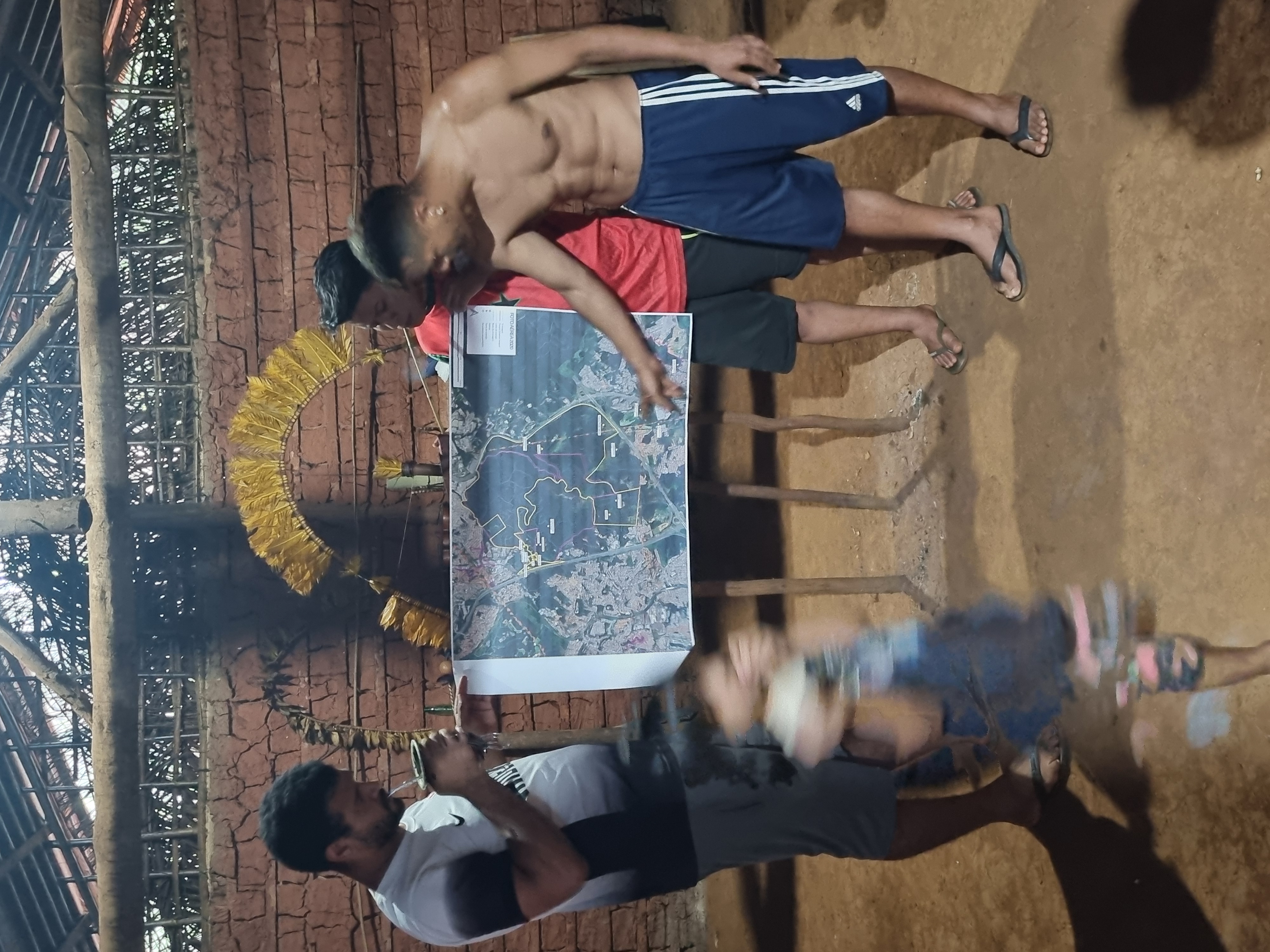
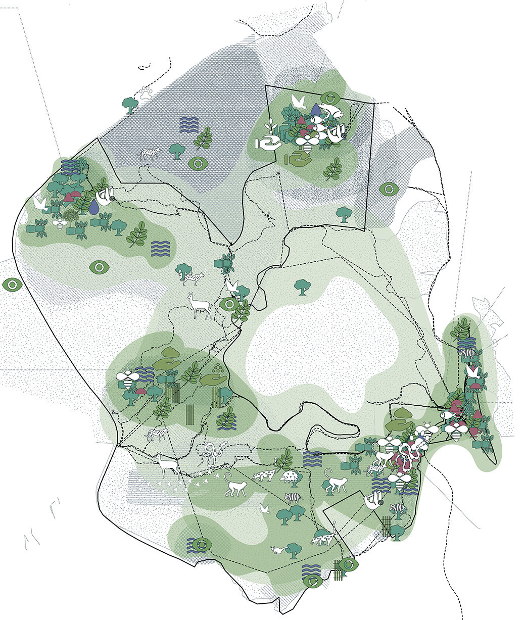
Para espacializar e visualizar essas práticas do cuidado e da reparação da terra, foram realizadas uma série de oficinas de mapeamento participativo na TI Jaraguá. Sobre uma grande tela de tecido, um mapa foi desenhado por muitas mãos, guiado por lideranças, ativistas e professores guaranis, xeramõi e xejaryi (líderes espirituais), xondaros e xondarias kuery (jovens líderes, guardiões do território).
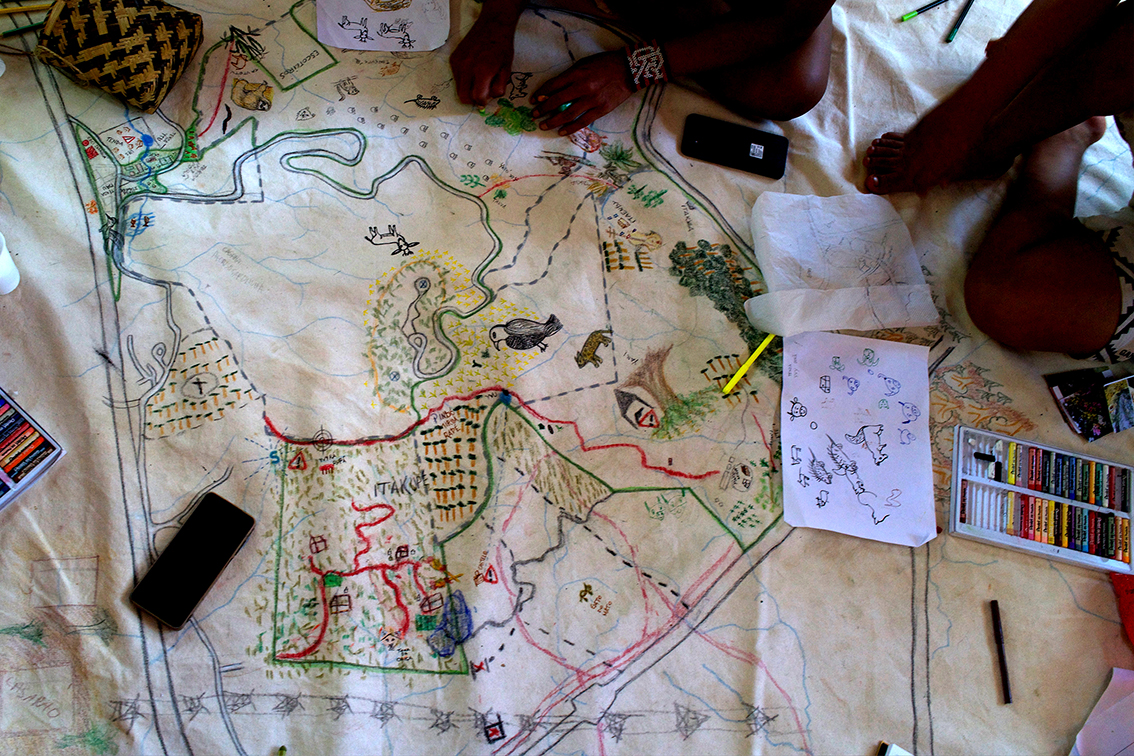
Traçando conhecimentos e vivências concretas no território, o mapa identifica áreas de fundamental importância para o habitar Guarani – como locais sagrados, caminhos tradicionais, áreas de proteção, áreas de reparação florestal e recuperação de espécies nativas – que não estão registradas em bases de dados oficiais e, por isso, tendem a ser invisibilizadas pelas políticas públicas.
Diferente do que mostram os mapas de Estado, onde a TI Jaraguá aparece como um grande espaço verde e vazio, este mapa mostra uma terra densamente habitada através das práticas do nhandereko, o modo de habitar Guarani.
Ao espacializar estes processos, o mapa joga luz em práticas muitas vezes invisibilizadas, principalmente o trabalho de cuidado cotidiano das mulheres que fincam raízes profundas para que Terra Indígena do Jaraguá cresça forte.
O nhandereko – as práticas espaciais e culturais do habitar e do cultivo da terra das comunidades Guarani – está em constante ameaça pela urbanização predatória de São Paulo, que segue devorando territórios, matas e rios em suas margens.
Enquanto a metrópole se expande, buscando os lucros do capital imobiliário, o território Guarani é cada vez mais cercado por infraestruturas urbanas, empreendimentos imobiliários e invasões. Mesmo demarcada, a TI segue sob crescente pressão espacial e política.
Durante as oficinas de mapeamento participativo, além das práticas espaciais do cuidado e da reparação da terra, foram identificados vários pontos de ameaça à integridade do território e das florestas do Jaraguá
Além da especulação imobiliária, ocorrências de violação de direitos territoriais da TI Jaraguá incluem desmatamento, fontes de águas obstruídas, caça illegal, expansão de plantações de eucalipto, poluição da água e do solo pelos bairros envoltórios, poluição sonora, queimadas ilegais, áreas com riscos de incêndio, entre outros.
Neste contexto, os mapas apresentados nesta plataforma digital buscam fornecer instrumentos de advocacia em apoio à luta dos Guarani pelos seus direitos territoriais e por reparações históricas e ambientais.
O mapa foi produzido pelo projeto Arquiteturas da Reparação: São Paulo Terra Indígena. Desenvolvido em parceria com lideranças e ativistas da T.I. Jaraguá, o projeto questiona visões tradicionais de cidade, território, memória, e patrimônio, buscando pensar como seres e elementos do mundo “mais-que-humano”, como as águas e as matas, podem ser incluídos como sujeitos patrimoniais dentro de um amplo processo de reparação histórica e socioambiental aos povos originários. O projeto foi realizado através de uma colaboração entre a T.I. Jaraguá, a agência autônoma, e o Chão Coletivo, por meio da plataforma Práticas Espaciais da Escola da Cidade.
T.I. Jaraguá
pesquisadores: Antony Karaí Poty, Thiago Henrique Karai Djekupe, Felipe Silva, e Richard Wera Mirim
consultores e entrevistas: Jurandir Tupã Jekupe Mirim, Márcio Werã Mirim, Irene Mendonça (Jaxuka Mirim), Daniel Werã Mirim, Cacica Ara Poty (Maria), Natalício Karaí, Tamikuã Txihi…, Coletivo Arandu Mirim (Antony Karaí Poty, Ciara Martins, Samara Para Martins)
participantes das oficinas: Antony Karaí Poty, Valdemir, Samara Para, Ciara Martins, Lenilson, Thiago Karaí Poty, Valdir, Felipe Silva, Osmar, Maria Ara Poty, brigadistas Lucas, Paulino, Adriano, Vander, Danilo e Luciano, Natalício Karaí, Antônia, Lucas, Pedrinho, Txai Suruí, Miguel, Antônio, jovens e crianças.
agência autônonoma
Paulo Tavares, Paula Marujo, Laura Pappalardo, Amanda Klajner e Julia Veras
Chão Coletivo
Beatrice Perracini Padovan, Giulio Michelino, Glória Kok, Isabela de Castilho Moraes e Laura Pappalardo
Plataforma Práticas Espaciais
Carol Tonetti e Gilberto Mariotti
design gráfico:
Cosmopolíticas Editoriais
finalização gráfica dos mapas:
Carolina Passos
CAU/SP (Programa de Assistência Técnica para Preservação do Patrimônio Cultural 2024, Termo de Fomento 016/2024, Ref. Projeto 406165)
APOIO
Design Museum, Future Observatory More-than-Human Fellowship